
1963 Map of Chignik B-3
USGS Topo · Published 1967About this map
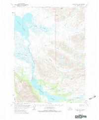
Black Lake and Chignik Lake anchor this 1963 field-annotated survey of the Alaska Peninsula, revealing a complex hydrological system of glacial runoff and mountain streams. The Alec River meanders through wide marshlands to feed the northern lake, while the West Fork Chignik River creates a prominent drainage corridor through the central valley. Between these large water bodies, the terrain rises sharply toward Range Peak and the surrounding highlands, where dozens of named tributaries like Cathedral Creek, Chiaktuak Creek, and Broad Creek descend through steep canyons. The map effectively documents the transition from lowland swamps and wet areas to high-elevation peaks, providing a clear record of the watershed before more modern developments. Local landmarks such as Cucumber Creek and Bearskin Creek offer specific points of reference for those studying the natural history or geographic nomenclature of this specific Alaskan quadrangle.
Find a feature on this map
16 named features on this map. Tap any name to fly to it.
Don’t see what you’re looking for? This feature index may not catch every label — zoom into the map to look around manually.
Map Details
Editions of this 1963 Chignik B-3 Map
2 editions found
Other maps of this area

1963 · Chignik B-2
USGS Topo · 1:63,360

1963 · Chignik C-3
USGS Topo · 1:63,360

1963 · Chignik A-4
USGS Topo · 1:63,360

1963 · Chignik C-4
USGS Topo · 1:63,360

1963 · Chignik A-2
USGS Topo · 1:63,360

1963 · Chignik B-4
USGS Topo · 1:63,360

1963 · Chignik C-2
USGS Topo · 1:63,360

1963 · Chignik A-3
USGS Topo · 1:63,360

1963 · Chignik
USGS Topo · 1:250,000
2020 · Chignik A-2 NW
USGS Topo · 1:25,000