
1963 Map of Chignik B-2
USGS Topo · Published 1967About this map
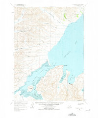
Chignik Lagoon serves as the focal point of this coastal survey, where the intricate network of tidal flats and points reveals a landscape defined by the salmon industry and maritime navigation. Evidence of local settlement and commerce is visible at the Cannery sites and the Seaplane Base Chignik, providing a record of the mid-century transportation and fishing infrastructure. The map details a rugged shoreline from Dago Point to Rabbit Point, while the interior is marked by Numerous creeks such as Neketa Creek and Thompson Creek flowing through valleys like McKinsey Valley. Genealogists and local historians can find specific landmarks including a Cem and various Cabin locations, alongside geographical features like Chignik Mtn and Eagle Rock that have long anchored the community on Anchorage Bay.
Find a feature on this map
54 named features on this map. Tap any name to fly to it.
Don’t see what you’re looking for? This feature index may not catch every label — zoom into the map to look around manually.
Map Details
Editions of this 1963 Chignik B-2 Map
2 editions found
Other maps of this area

1963 · Chignik C-3
USGS Topo · 1:63,360

1963 · Chignik B-1
USGS Topo · 1:63,360

1963 · Chignik A-2
USGS Topo · 1:63,360

1963 · Chignik C-1
USGS Topo · 1:63,360
1963 · Chignik A-1
USGS Topo · 1:63,360

1963 · Chignik C-2
USGS Topo · 1:63,360

1963 · Chignik A-3
USGS Topo · 1:63,360

1963 · Chignik B-3
USGS Topo · 1:63,360

1963 · Chignik
USGS Topo · 1:250,000
2020 · Chignik B-2 NE
USGS Topo · 1:25,000