
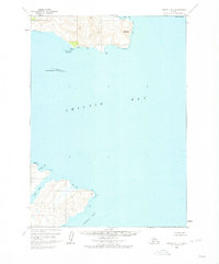
1963 Map of Chignik B-1
USGS Topo · Published 1967About this map
Cape Kumliun and Weasel Mountain dominate the northern peninsula of this coastal Alaska survey, defining a jagged shoreline shaped by deep inlets and narrow points. This mid-century study by the U.S. Geological Survey depicts the complex hydrography of the region, where the expansive Chignik Bay meets smaller, protected waters like Hook Bay and Lumber Bay. The map relies on 1957 aerial photography and 1963 field annotations to trace the uninhabited terrain, showing no roads or trails through the mountains.
Find a feature on this map
10 named features on this map. Tap any name to fly to it.
Don’t see what you’re looking for? This feature index may not catch every label — zoom into the map to look around manually.
Map Details
Editions of this 1963 Chignik B-1 Map
2 editions found
Other maps of this area

1951 · Sutwik Island
USGS Topo · 1:250,000

1963 · Chignik B-2
USGS Topo · 1:63,360

1963 · Chignik A-2
USGS Topo · 1:63,360

1963 · Chignik C-1
USGS Topo · 1:63,360

1963 · Sutwik Island B-6
USGS Topo · 1:63,360
1963 · Chignik A-1
USGS Topo · 1:63,360

1963 · Chignik C-2
USGS Topo · 1:63,360

1963 · Sutwik Island
USGS Topo · 1:250,000

1963 · Sutwik Island C-6
USGS Topo · 1:63,360

1963 · Chignik
USGS Topo · 1:250,000