
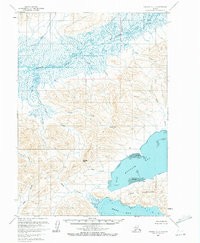
1963 Map of Chignik C-1
USGS Topo · Published 1967About this map
The braided waters of the Meshik River dominate the northern landscape of this Alaska Peninsula coastal region, flowing through a vast network of wetlands and seasonal drainages. To the south, the deep indentation of Kujulik Bay is framed by the prominent Cape Kumliun, where tidal flats and steep coastal terrain meet. This 1963 field-annotated survey reveals a wilderness defined by its water systems, including the creatively named Plenty Bear Creek and Blue Violet Creek. A few isolated structures, such as a Cabin near the mouth of Rudy Creek and another at the base of Portage Pass, mark the rare evidence of human presence in this maritime environment. The intricate topography suggests historical transit routes through mountain gaps like Black Pass, which connects the interior drainages to the coastal bays.
Find a feature on this map
22 named features on this map. Tap any name to fly to it.
Don’t see what you’re looking for? This feature index may not catch every label — zoom into the map to look around manually.
Map Details
Editions of this 1963 Chignik C-1 Map
2 editions found
Other maps of this area

1951 · Sutwik Island
USGS Topo · 1:250,000

1963 · Chignik B-2
USGS Topo · 1:63,360

1963 · Chignik B-1
USGS Topo · 1:63,360

1963 · Sutwik Island B-6
USGS Topo · 1:63,360

1963 · Chignik C-2
USGS Topo · 1:63,360

1963 · Sutwik Island
USGS Topo · 1:250,000

1963 · Sutwik Island C-6
USGS Topo · 1:63,360

1963 · Chignik
USGS Topo · 1:250,000

1963 · Chignik D-1
USGS Topo · 1:63,360
1963 · Sutwik Island D-6
USGS Topo · 1:63,360