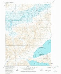
1963 Map of Chignik C-1
USGS Topo · Published 1972About this map
The Meshik River dominates the northern reaches of this coastal landscape, winding through a complex network of wetlands and tributaries. The terrain transitions from these low-lying alluvial plains to the sharp ridges of the Alaska Peninsula, where narrow corridors like Black Pass and Portage Pass provide the only natural passage between the interior and the sea. Along the southern coastline, the waters of Kujulik Bay and Hook Bay are separated by the prominent landmass of Cape Kumliun, a significant landmark for maritime travel in the region.
Find a feature on this map
21 named features on this map. Tap any name to fly to it.
Don’t see what you’re looking for? This feature index may not catch every label — zoom into the map to look around manually.
Map Details
Editions of this 1963 Chignik C-1 Map
2 editions found
Other maps of this area

1951 · Sutwik Island
USGS Topo · 1:250,000

1963 · Chignik B-2
USGS Topo · 1:63,360

1963 · Chignik B-1
USGS Topo · 1:63,360

1963 · Chignik C-1
USGS Topo · 1:63,360

1963 · Sutwik Island B-6
USGS Topo · 1:63,360

1963 · Chignik C-2
USGS Topo · 1:63,360

1963 · Sutwik Island
USGS Topo · 1:250,000

1963 · Sutwik Island C-6
USGS Topo · 1:63,360

1963 · Chignik
USGS Topo · 1:250,000

1963 · Chignik D-1
USGS Topo · 1:63,360