
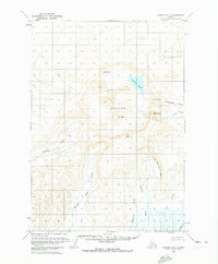
1963 Map of Chignik D-1
USGS Topo · Published 1968About this map
The massive Aniakchak Crater dominates this mid-century Alaskan survey, revealing a landscape defined by volcanic geology. Within the caldera, the waters of Surprise Lake sit surrounded by fields of lava, with the prominent Vent Mtn and Half Cone rising from the basin floor. The drainage system is particularly striking, as the Aniakchak River breaches the eastern rim at a narrow pass known as The Gates. The southern reaches of the map track the rugged descent of the terrain through The Garden Wall, where numerous named tributaries such as Rainbow Creek and Waterfall Creek flow toward the Meshik River. This document records the area as it appeared in the early 1960s, prior to its later federal designations, capturing a remote wilderness where landforms like Aniakchak Peak were primarily defined by their natural topography rather than human settlement.
Find a feature on this map
17 named features on this map. Tap any name to fly to it.
Don’t see what you’re looking for? This feature index may not catch every label — zoom into the map to look around manually.
Map Details
Editions of this 1963 Chignik D-1 Map
2 editions found
Other maps of this area

1943 · Ugashik
USGS Topo · 1:250,000

1948 · Ugashik
USGS Topo · 1:250,000

1949 · Ugashik
USGS Topo · 1:250,000

1951 · Bristol Bay
USGS Topo · 1:250,000

1951 · Sutwik Island
USGS Topo · 1:250,000

1963 · Ugashik A-6
USGS Topo · 1:63,360

1963 · Chignik C-1
USGS Topo · 1:63,360

1963 · Bristol Bay
USGS Topo · 1:250,000
1963 · Bristol Bay A-2
USGS Topo · 1:63,360

1963 · Bristol Bay A-1
USGS Topo · 1:63,360