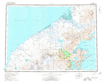
1963 Map of Bristol Bay A-2
USGS Topo · Published 1967About this map
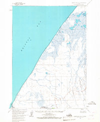
Bristol Bay dominates the western coastline of this 1960s study, where the waters of the Bering Sea meet the complex hydrology of the Alaska Peninsula. The shoreline is characterized by extensive Tidal Flats, which separate the open bay from inland water features like Hook Lagoon. Further south, Reindeer Creek winds through a landscape saturated with small ponds and marshes. The map identifies several localized points of interest such as Sherry, Dubb, and Quirk, which represent specific landmarks or surveyed locations in this otherwise uninhabited coastal stretch. Compiled from aerial photography taken in 1957 and field annotated in 1963, this survey provides a look at the natural drainage patterns and coastal landforms before significant modern changes, documenting remote locations like Valet, Tech, and Ultra for geographic reference.
Find a feature on this map
14 named features on this map. Tap any name to fly to it.
Don’t see what you’re looking for? This feature index may not catch every label — zoom into the map to look around manually.
Map Details
Editions of this 1963 Bristol Bay A-2 Map
2 editions found

Other maps of this area

1951 · Bristol Bay
USGS Topo · 1:250,000
1963 · Bristol Bay
USGS Topo · 1:250,000
1963 · Chignik D-3
USGS Topo · 1:63,360
1963 · Bristol Bay A-1
USGS Topo · 1:63,360
1963 · Chignik
USGS Topo · 1:250,000
1963 · Chignik D-1
USGS Topo · 1:63,360
1963 · Chignik D-2
USGS Topo · 1:63,360
1963 · Bristol Bay B-1
USGS Topo · 1:63,360

1967 · Bristol Bay
USGS Topo · 1:250,000

2019 · Bristol Bay A-1 NW
USGS Topo · 1:25,000