1948 Map of Ugashik
USGS Topo · Published 1954About this map
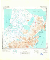
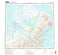
The Alaska Peninsula separates the waters of Bristol Bay from the North Pacific in this mid-century reconnaissance, revealing a landscape defined by volcanic peaks and expansive drainage systems. The settlement of Kanatak sits on the eastern shore near Lee's Cabin, while the western coast is marked by Pilot Point and the complex estuary of Ugashik Bay. The interior is dominated by a chain of large freshwater bodies, including Becharof Lake, Upper Ugashik Lake, and Lower Ugashik Lake, which feed the Ugashik River. Volcanic activity is evident through features like Mt Chiginagak, Mt Peulik, and the geologically curious The Gas Rocks on the shores of Becharof. Numerous family-named or descriptive landmarks like Painter Creek, Mother Goose Lake, and Blue Barbara Creek suggest the seasonal fishing and trapping patterns that have long supported the region's inhabitants.
Find a feature on this map
86 named features on this map. Tap any name to fly to it.
Don’t see what you’re looking for? This feature index may not catch every label — zoom into the map to look around manually.
Map Details
Editions of this 1948 Ugashik Map
This is the sole edition of this map. No revisions or reprints were ever made.
Historical Maps of Pilot Point Through Time
4 maps found