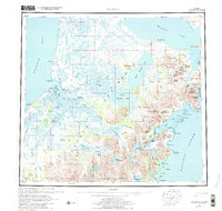
1963 Map of Ugashik
USGS Topo · Published 1976About this map
The Alaska Peninsula stretches between the high peaks of the Aleutian Range and the coastal flats of Bristol Bay in this mid-century survey. Settlements like Pilot Point and Ugashik anchor the western coast near the mouth of Ugashik Bay, while the eastern shore at Kanatak borders the Pacific Ocean. This geography showcases a landscape of dramatic extremes, from the massive inland basin of Becharof Lake to the volcanic heights of Mount Peulik and Mount Chiginagak.
Find a feature on this map
110 named features on this map. Tap any name to fly to it.
Don’t see what you’re looking for? This feature index may not catch every label — zoom into the map to look around manually.
Map Details
Editions of this 1963 Ugashik Map
3 editions found

Other maps of this area

1943 · Ugashik
USGS Topo · 1:250,000

1945 · Nushagak Bay
USGS Topo · 1:250,000

1948 · Mt Katmai
USGS Topo · 1:250,000

1948 · Ugashik
USGS Topo · 1:250,000

1949 · Ugashik
USGS Topo · 1:250,000

1949 · Nushagak Bay
USGS Topo · 1:250,000

1951 · Bristol Bay
USGS Topo · 1:250,000

1951 · Trinity Islands
USGS Topo · 1:250,000

1951 · Mt Katmai
USGS Topo · 1:250,000

1951 · Karluk
USGS Topo · 1:250,000