
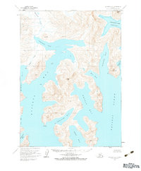
1963 Map of Chignik A-2
USGS Topo · Published 1967About this map
The complex coastline of the Alaska Peninsula is documented here during a period of extensive aerial photogrammetric mapping. Deep inlets and fjord-like passages dominate the landscape, notably Portage Bay and the intricately branched Kuiukta Bay. The topography is defined by high peaks and ridges, including Chignik Mtn in the northeast and Virgin Peak centrally located above Sweater Bay. This 1963 field-annotated survey reveals a wilderness defined by water and rock, where names like Devils Bay and Ross Cove mark the shoreline of the Pacific Ocean. Inland, freshwater sources like Metrofanis Creek and Spoon Creek flow through valleys between unnamed summits, while small landmarks such as Ship Mountain and Necessity Cove provide essential orientation along the eastern reaches of Warner Bay.
Find a feature on this map
25 named features on this map. Tap any name to fly to it.
Don’t see what you’re looking for? This feature index may not catch every label — zoom into the map to look around manually.
Map Details
Editions of this 1963 Chignik A-2 Map
2 editions found
Other maps of this area

1951 · Stepovak Bay
USGS Topo · 1:250,000

1963 · Stepovak Bay D-2
USGS Topo · 1:63,360

1963 · Chignik B-2
USGS Topo · 1:63,360

1963 · Chignik B-1
USGS Topo · 1:63,360
1963 · Chignik A-1
USGS Topo · 1:63,360

1963 · Chignik A-3
USGS Topo · 1:63,360

1963 · Chignik B-3
USGS Topo · 1:63,360

1963 · Chignik
USGS Topo · 1:250,000
1963 · Stepovak Bay D-3
USGS Topo · 1:63,360

1963 · Stepovak Bay
USGS Topo · 1:250,000