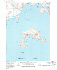
1963 Map of Stepovak Bay D-3
USGS Topo · Published 1968About this map
Mitrofania Island dominates this coastal survey, serving as a geographic anchor within the Pacific Ocean waters of the Aleutian Range foothills. The map documents a sparse but significant human presence along the shoreline, particularly at Mitrofania and the nearby Mitrofania Harbor. A Church and an area of Ruins near Stirni Point suggest a long-standing pattern of settlement and maritime activity. The rugged coastline is defined by several protected inlets, including Sosbee Bay and Anchor Bay, which would have been vital for small craft navigating these remote Alaskan waters. Further north, the settlement of Ivan sits at the head of Ivan Bay, where Long Beach stretches toward the mainland interior. These details, including isolated landmarks like a Cabin on the island and the small Brother Islands, provide a clear record of the area's mid-century coastal character.
Find a feature on this map
28 named features on this map. Tap any name to fly to it.
Don’t see what you’re looking for? This feature index may not catch every label — zoom into the map to look around manually.
Map Details
Editions of this 1963 Stepovak Bay D-3 Map
2 editions found
Other maps of this area

1951 · Stepovak Bay
USGS Topo · 1:250,000

1963 · Stepovak Bay D-2
USGS Topo · 1:63,360

1963 · Chignik A-4
USGS Topo · 1:63,360

1963 · Stepovak Bay D-4
USGS Topo · 1:63,360

1963 · Chignik A-2
USGS Topo · 1:63,360

1963 · Chignik A-3
USGS Topo · 1:63,360

1963 · Chignik
USGS Topo · 1:250,000

1963 · Stepovak Bay
USGS Topo · 1:250,000

1969 · Stepovak Bay
USGS Topo · 1:250,000
2020 · Stepovak Bay D-2 NW
USGS Topo · 1:25,000