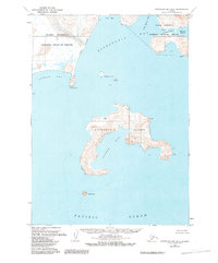
1963 Map of Stepovak Bay D-3
USGS Topo · Published 1984About this map
Mitrofania Island dominates the central portion of this coastal survey, appearing as a complex landmass defined by its deep indents and numerous small summits. The map provides a look at the remote Aleutian landscape in the early 1960s, a period when human presence was limited to scattered coastal outposts. To the north, the Alaska Peninsula shoreline is marked by Ivan Bay and Long Beach, where remnants of activity are noted by the presence of Ruins and a Church near Stirni Point. These markers, along with isolated labels for a Cabin, suggest the remnants of seasonal fishing camps or indigenous settlements that relied on the surrounding waters. The waters of Mitrofania Bay and Sosbee Bay separate the island from the mainland, highlighting a terrain where the marine environment of the Pacific Ocean is the primary influence on geography and travel.
Find a feature on this map
27 named features on this map. Tap any name to fly to it.
Don’t see what you’re looking for? This feature index may not catch every label — zoom into the map to look around manually.
Map Details
Editions of this 1963 Stepovak Bay D-3 Map
2 editions found
Other maps of this area

1951 · Stepovak Bay
USGS Topo · 1:250,000

1963 · Stepovak Bay D-2
USGS Topo · 1:63,360

1963 · Chignik A-4
USGS Topo · 1:63,360

1963 · Stepovak Bay D-4
USGS Topo · 1:63,360

1963 · Chignik A-2
USGS Topo · 1:63,360

1963 · Chignik A-3
USGS Topo · 1:63,360

1963 · Chignik
USGS Topo · 1:250,000
1963 · Stepovak Bay D-3
USGS Topo · 1:63,360

1963 · Stepovak Bay
USGS Topo · 1:250,000

1969 · Stepovak Bay
USGS Topo · 1:250,000