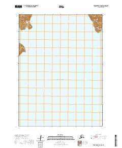
2020 Map of Stepovak Bay D-2 NW
USGS Topo · Published 2020About this map
Cape Ikti and the coastal fringes of the Aleutian Range dominate the northern margins of this maritime survey, where the rugged landmass of the Alaska Peninsula meets the open water. The map is defined by the vast reach of the Gulf of Alaska, which occupies the majority of the sheet, illustrating the isolation of this stretch of coastline. In the upper reaches, the protected waters of Kuiukta Bay cut into the mountainous terrain, providing a natural harbor and contrast to the exposed southern capes. This 2020 edition captures the topographical character of a region where high-relief peaks quickly descend into deep ocean waters, a landscape largely shaped by its position along the North Pacific.
Find a feature on this map
9 named features on this map. Tap any name to fly to it.
Don’t see what you’re looking for? This feature index may not catch every label — zoom into the map to look around manually.
Map Details
Editions of this 2020 Stepovak Bay D-2 NW Map
This is the sole edition of this map. No revisions or reprints were ever made.
Other maps of this area

1951 · Stepovak Bay
USGS Topo · 1:250,000

1963 · Stepovak Bay D-2
USGS Topo · 1:63,360

1963 · Chignik A-2
USGS Topo · 1:63,360

1963 · Chignik A-3
USGS Topo · 1:63,360

1963 · Chignik
USGS Topo · 1:250,000
1963 · Stepovak Bay D-3
USGS Topo · 1:63,360

1963 · Stepovak Bay
USGS Topo · 1:250,000

1969 · Stepovak Bay
USGS Topo · 1:250,000
2020 · Stepovak Bay D-3 SE
USGS Topo · 1:25,000
2020 · Chignik A-2 SW
USGS Topo · 1:25,000