
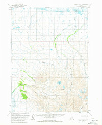
1963 Map of Chignik C-3
USGS Topo · Published 1967About this map
Black Peak towers over the southern landscape of this mid-century survey, anchoring a wilderness defined by glacial drainages and volcanic features on the Alaska Peninsula. The topography reveals a complex network of waterways, including the winding Charles Creek and Yellow Bluff Creek, which flow through largely unsurveyed lands predetermined by the Bureau of Land Management. A significant geological highlight is found at Crater Creek, while the vivid Purple Lake sits tucked into the high elevations north of the peak. This 1963 field-annotated record captures the area before modern development, showing a land of stark relief where Ash Creek and Cathedral Creek carve through the Seward Meridian. The map provides a precise look at the hydrology of the Lake and Peninsula region, from the sedimentary reaches of Red Bluff Creek to the remote headwaters of Milk Creek.
Find a feature on this map
9 named features on this map. Tap any name to fly to it.
Don’t see what you’re looking for? This feature index may not catch every label — zoom into the map to look around manually.
Map Details
Editions of this 1963 Chignik C-3 Map
2 editions found
Other maps of this area

1963 · Chignik B-2
USGS Topo · 1:63,360

1963 · Chignik C-4
USGS Topo · 1:63,360

1963 · Chignik B-4
USGS Topo · 1:63,360
1963 · Chignik D-4
USGS Topo · 1:63,360

1963 · Chignik D-3
USGS Topo · 1:63,360

1963 · Chignik C-2
USGS Topo · 1:63,360

1963 · Chignik B-3
USGS Topo · 1:63,360

1963 · Chignik
USGS Topo · 1:250,000

1963 · Chignik D-2
USGS Topo · 1:63,360
2020 · Chignik D-3 SW
USGS Topo · 1:25,000