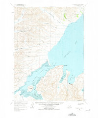
1963 Map of Chignik B-2
USGS Topo · Published 1975About this map
The coastal fishing and aviation hub of Chignik serves as the focal point of this coastal Alaska survey, detailing a landscape defined by the tidal reaches of Chignik Lagoon and the sheltered waters of Anchorage Bay. The map reveals a remote maritime economy at mid-century, where a Cannery and Seaplane Base underscore the region's reliance on both the sea and the air for transit and industry. Beyond the main settlement, several Cabins are scattered along the rugged coastline and inland valleys, suggesting a spread of seasonal fishing or trapping activity.
Find a feature on this map
51 named features on this map. Tap any name to fly to it.
Don’t see what you’re looking for? This feature index may not catch every label — zoom into the map to look around manually.
Map Details
Editions of this 1963 Chignik B-2 Map
2 editions found
Other maps of this area

1963 · Chignik B-2
USGS Topo · 1:63,360

1963 · Chignik C-3
USGS Topo · 1:63,360

1963 · Chignik B-1
USGS Topo · 1:63,360

1963 · Chignik A-2
USGS Topo · 1:63,360

1963 · Chignik C-1
USGS Topo · 1:63,360
1963 · Chignik A-1
USGS Topo · 1:63,360

1963 · Chignik C-2
USGS Topo · 1:63,360

1963 · Chignik A-3
USGS Topo · 1:63,360

1963 · Chignik B-3
USGS Topo · 1:63,360

1963 · Chignik
USGS Topo · 1:250,000