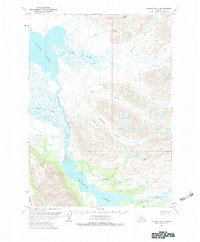
1963 Map of Chignik B-3
USGS Topo · Published 1983About this map
Black Lake and the winding Alec River dominate this 1963 survey of the Alaska Peninsula, showing a landscape defined by complex hydrology and glaciated peaks. The map details the transition from the expansive waters of the north down through the Chignik River system toward Chignik Lake. Notable terrain features such as Bearskin Gl and the prominent Range Peak provide reference points for the numerous drainages like Cathedral Creek and Chiaktuak Creek that feed into the central basin. This topography, mapped from 1962 aerial photography, documents the undisturbed natural state of this region before any significant human infrastructure. The intricate network of alluvial fans and marshy reaches near the West Fork illustrates the dynamic nature of the peninsula's interior waterways during the early 1960s.
Find a feature on this map
17 named features on this map. Tap any name to fly to it.
Don’t see what you’re looking for? This feature index may not catch every label — zoom into the map to look around manually.
Map Details
Editions of this 1963 Chignik B-3 Map
2 editions found
Other maps of this area

1963 · Chignik B-2
USGS Topo · 1:63,360

1963 · Chignik C-3
USGS Topo · 1:63,360

1963 · Chignik A-4
USGS Topo · 1:63,360

1963 · Chignik C-4
USGS Topo · 1:63,360

1963 · Chignik A-2
USGS Topo · 1:63,360

1963 · Chignik B-4
USGS Topo · 1:63,360

1963 · Chignik C-2
USGS Topo · 1:63,360

1963 · Chignik A-3
USGS Topo · 1:63,360

1963 · Chignik B-3
USGS Topo · 1:63,360

1963 · Chignik
USGS Topo · 1:250,000