Old Maps of Port Alsworth, Alaska for Metal Detecting
Plan your next treasure hunt with 5 historic maps of Port Alsworth. Find old homesites, ghost towns, trails, and gathering spots that may be lost to time — perfect for identifying promising metal detecting locations.
- Locate forgotten sites: Uncover places like long-lost settlements, abandoned rail lines, or gathering spots.
- Plan better hunts: Use map overlays combined with LiDAR or satellite views to narrow in on historically rich areas.
- Made for detectorists: Thousands of hobbyists use these maps to discover relics, coins, and hidden history.
Use these historic maps to boost your research and find new opportunities beneath the surface of Port Alsworth.
Port Alsworth, AK maps
(5)- 1946 Map of Lake Clark, 1954 Print
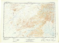
 1946 Lake Clark1954 Print · USGSInterior Alaska during the mid-forties and early fifties reveals a remote landscape of glacial lakes and mountain peaks. You can trace early settlements at Nondalton, find the Old Village trail network, and locate the Tanalian Point Landing Field near the shores of Lake Clark.2 unique versions available
 - 1951 Map of Lake Clark
 1951 Lake Clark1951 Print · USGSThe Lake Clark region of the Alaskan interior was a remote frontier in the early 1950s, defined by high peaks and sprawling river systems. Researchers can trace historic travel routes like the Native Trail and locate isolated settlements at Old Village or Nondalton.2 unique versions available
 - 1954 Map of Lake Clark A-4, 1965 Print
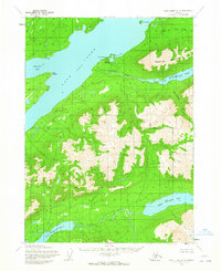 1954 Lake Clark A-41965 Print · USGSCoastal Lake Clark in the mid-fifties is a landscape of isolated settlements and vital bush pilot outposts before the modern era. Researchers can locate Port Alsworth on its point, the Tanalian Point Landing Field, and remote water bodies like Kontrashibuna Lake.2 unique versions available
 - 1958 Map of Lake Clark, 1967 Print
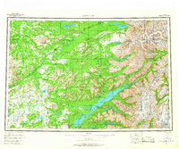 1958 Lake Clark1967 Print · USGSLake Clark and the surrounding wilderness are captured during the 1950s as a remote frontier of rivers and volcanic peaks. Researchers can locate early outposts like Port Alsworth and trace the paths of the Summit Trail or the waters of Kontrashibuna Lake.4 unique versions available
 - 2018 Map of Lake Clark A-4 NW, 2018 Print
 2018 Lake Clark A-4 NW2018 Print · USGSPort Alsworth stands on the shores of Lake Clark in the late 2010s, marking a rare point of human infrastructure. Trace the layout of this bush community through its dual landing strips at Port Alsworth Airport and Wilder/Natwick LLC Airport.
End of results
Showing maps 1-5 of 5
Frequently asked questions
- What are the different types of historical maps available for Port Alsworth?
- What is the oldest map of Port Alsworth?
- Where can I purchase historical maps of Port Alsworth for my home or office?
- Where can I download high-res historical maps of Port Alsworth?
- Are there historical topographic maps available for Port Alsworth?
- Is there historical aerial imagery available for Port Alsworth?
- Where are historical maps of Port Alsworth sourced from?