Old Maps of Port Heiden, Alaska for Academic Research
Study the evolution of Port Heiden with 5 high-resolution historic maps. Whether you're teaching, researching, or modeling changes in land use, these maps provide essential visual documentation of urban, environmental, and geographic change.
- Analyze long-term change: Track patterns in development, transportation, and natural features.
- Ideal for environmental or urban studies: Support academic projects with primary historical map data.
- Use in the classroom or lab: Educators and researchers rely on these maps to bring historical context to life.
These maps are a powerful tool for teaching, research, and visualizing how Port Heiden has changed over the decades.
Port Heiden, AK maps
(5)- 1963 Map of Chignik D-3, 1967 Print
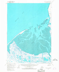 1963 Chignik D-31967 Print · USGSThe northern coast of the Alaska Peninsula is captured here in the early sixties, centered on the inlet of Port Heiden. Local historians can trace the settlement at Meshik, locate the nearby Cem, and see the coastal lights on Chistiakof Island.2 unique versions available
 - 1963 Map of Chignik, 1968 Print
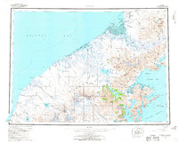 1963 Chignik1968 Print · USGSThe Alaska Peninsula in the mid-sixties is a world of volcanic peaks and isolated fishing outposts. Genealogists and historians can trace the foundations of Chignik and Meshik or locate remote Cabins near Chignik Lake and the Meshik River.3 unique versions available
 - 1963 Map of Chignik D-2, 1968 Print
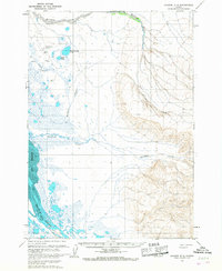 1963 Chignik D-21968 Print · USGSCoastal Alaska during the early sixties is captured here, showing the remote wetlands surrounding the Meshik River. You can trace historical aviation infrastructure and landmarks like the Port Heiden Airfield, Hendrickson Lake, and the summit at Witch.2 unique versions available
 - 2020 Map of Chignik D-2 NW, 2020 Print
 2020 Chignik D-2 NW2020 Print · USGSPort Heiden and the surrounding Alaska Peninsula landscape are shown here in 2020. Local history researchers can trace the town’s remote infrastructure through labels for Port Heiden Airport, Oil Well Road, and Barabara Cr.
 - 2020 Map of Chignik D-3 NE, 2020 Print
 2020 Chignik D-3 NE2020 Print · USGSCoastal life on the Alaska Peninsula comes into focus in this recent survey of the Bristol Bay shoreline. Researchers can trace local infrastructure around Port Heiden and follow routes like Oil Well Road and Cold Pile Road through the coastal wetlands.
End of results
Showing maps 1-5 of 5
Frequently asked questions
- What are the different types of historical maps available for Port Heiden?
- What is the oldest map of Port Heiden?
- Where can I purchase historical maps of Port Heiden for my home or office?
- Where can I download high-res historical maps of Port Heiden?
- Are there historical topographic maps available for Port Heiden?
- Is there historical aerial imagery available for Port Heiden?
- Where are historical maps of Port Heiden sourced from?