1900s (20th Century) Maps of Port Heiden, Alaska
Explore 3 historic maps of Port Heiden from the 1900s (20th Century). These maps offer a rare glimpse into what life looked like during the 1900s — showing old roads, neighborhoods, homes, and landmarks that have changed or disappeared over time.
Whether you're researching your family's past, planning a metal detecting trip, or studying how Port Heiden's landscape evolved across the 1900s, these high-resolution maps are a powerful tool for exploring the history of this region.
- Focus on a specific era: All maps on this page are from the 1900s, giving you a focused view of this time period.
- See what’s changed: Compare century-old streets, trails, and buildings to today's modern landscape using overlays and satellite layers.
- Research with precision: Use these maps for genealogy, historical research, land use analysis, or educational projects.
- View, download, or print: Maps are fully viewable online in high resolution, and can be downloaded or printed for your own records.
Start exploring Port Heiden's history through authentic maps from the 1900s. This is your window into the past.
Port Heiden, AK maps
(3)- 1963 Map of Chignik D-3, 1967 Print
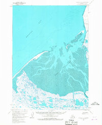 1963 Chignik D-31967 Print · USGSThe northern coast of the Alaska Peninsula is captured here in the early sixties, centered on the inlet of Port Heiden. Local historians can trace the settlement at Meshik, locate the nearby Cem, and see the coastal lights on Chistiakof Island.2 unique versions available
 - 1963 Map of Chignik, 1968 Print
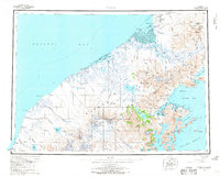 1963 Chignik1968 Print · USGSThe Alaska Peninsula in the mid-sixties is a world of volcanic peaks and isolated fishing outposts. Genealogists and historians can trace the foundations of Chignik and Meshik or locate remote Cabins near Chignik Lake and the Meshik River.3 unique versions available
 - 1963 Map of Chignik D-2, 1968 Print
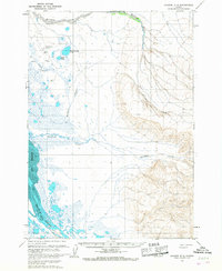 1963 Chignik D-21968 Print · USGSCoastal Alaska during the early sixties is captured here, showing the remote wetlands surrounding the Meshik River. You can trace historical aviation infrastructure and landmarks like the Port Heiden Airfield, Hendrickson Lake, and the summit at Witch.2 unique versions available
End of results
Showing maps 1-3 of 3
Frequently asked questions
- What are the different types of historical maps available for Port Heiden?
- What is the oldest map of Port Heiden?
- Where can I purchase historical maps of Port Heiden for my home or office?
- Where can I download high-res historical maps of Port Heiden?
- Are there historical topographic maps available for Port Heiden?
- Is there historical aerial imagery available for Port Heiden?
- Where are historical maps of Port Heiden sourced from?