Old Maps of Alpine, Alaska for Genealogy
Trace your family roots with 6 historic maps of Alpine. These high-res maps reveal old neighborhoods, homesites, landmarks, and streets — helping you uncover where your ancestors lived and how the area evolved over time.
- Explore historic neighborhoods: Identify where your relatives may have lived in the 1800s or 1900s.
- Compare maps over time: Trace the changes in streets, buildings, and landmarks for multi-generational research.
- Perfect for genealogy & ancestry research: Used by family historians and researchers to map out lineage and migration.
These maps are an incredible resource for exploring your personal connection to Alpine's past.
Alpine, AK maps
(6)- 1951 Map of Harrison Bay
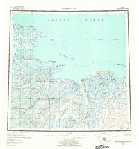
 1951 Harrison Bay1951 Print · USGSThe North Slope of Alaska during the early postwar period reveals a wilderness of massive river deltas and federal petroleum reserves. Researchers can trace the remote waterways of the Colville River and find isolated landmarks like the Trading Post and Ocean Point.
 - 1955 Map of Harrison Bay, 1961 Print
 1955 Harrison Bay1961 Print · USGSThe Arctic coastline of the North Slope appears here in the mid-1950s, centered on the expansive delta of the Colville River. Researchers can trace the historic Esook Trading Post (Aban'd) and explore the remote Eskimo Islands and Cape Halkett.8 unique versions available
 - 1955 Map of Harrison Bay B-2, 1967 Print
 1955 Harrison Bay B-21967 Print · USGSThe Arctic coastline of the North Slope appears here in the mid-fifties, dominated by the shifting waters of the Colville River Delta. Researchers can trace the vast Naval Petroleum Reserve No 4 and landmarks like Oil Lake and Kachemachi Mound.2 unique versions available
 - 1962 Map of Harrison Bay B-2
 1962 Harrison Bay B-21962 Print · USGSThe North Slope coast comes into focus during the early sixties, showing the vast transition from tundra to the Arctic sea. Researchers can trace the shifting distributaries of the Colville River Delta and the boundaries of Naval Petroleum Reserve No 4.
 - 2016 Map of Harrison Bay B-2 SW, 2016 Print
 2016 Harrison Bay B-2 SW2016 Print · USGSCovers Alpine, including North Slope, United States, and other nearby areas
 - 2020 Map of Harrison Bay B-2 SW, 2020 Print
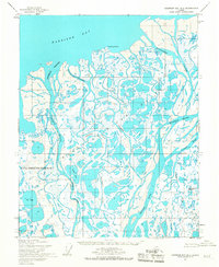
 2020 Harrison Bay B-2 SW2020 Print · USGSThe Colville River Delta comes into focus in this recent survey of Alaska's North Slope, showing the intersection of industrial operations and arctic wetlands. Researchers can trace the layout of Alpine and the Alpine Airstrip alongside the winding Nechelik Channel.
End of results
Showing maps 1-6 of 6
Top cities near Alpine
Frequently asked questions
- What are the different types of historical maps available for Alpine?
- What is the oldest map of Alpine?
- Where can I purchase historical maps of Alpine for my home or office?
- Where can I download high-res historical maps of Alpine?
- Are there historical topographic maps available for Alpine?
- Is there historical aerial imagery available for Alpine?
- Where are historical maps of Alpine sourced from?