1900s (20th Century) Maps of Point Hope, Alaska
Explore 4 historic maps of Point Hope from the 1900s (20th Century). These maps offer a rare glimpse into what life looked like during the 1900s — showing old roads, neighborhoods, homes, and landmarks that have changed or disappeared over time.
Whether you're researching your family's past, planning a metal detecting trip, or studying how Point Hope's landscape evolved across the 1900s, these high-resolution maps are a powerful tool for exploring the history of this region.
- Focus on a specific era: All maps on this page are from the 1900s, giving you a focused view of this time period.
- See what’s changed: Compare century-old streets, trails, and buildings to today's modern landscape using overlays and satellite layers.
- Research with precision: Use these maps for genealogy, historical research, land use analysis, or educational projects.
- View, download, or print: Maps are fully viewable online in high resolution, and can be downloaded or printed for your own records.
Start exploring Point Hope's history through authentic maps from the 1900s. This is your window into the past.
Point Hope, AK maps
(4)- 1952 Map of Point Hope, 1953 Print
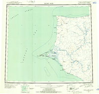 1952 Point Hope1953 Print · USGSCoastal Alaska at the mid-century shows a sparse but vital network of Arctic settlements and resource extraction points. Researchers can trace the Winter Trail past Wevok to the Corwin Mine or locate the Cem near the Point Hope village.
 - 1952 Map of Point Hope B-3, 1959 Print
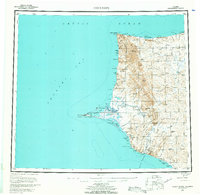
 1952 Point Hope B-31959 Print · USGSPoint Hope sits at the edge of the Arctic in the early fifties, a vital coastal settlement defined by its relationship with the Chukchi Sea. Researchers can locate the historic Mission and Cem, or trace the remains of earlier habitations at Ipiutak and Jabbertown.3 unique versions available
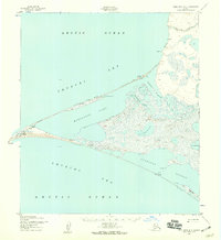
 - 1955 Map of Point Hope, 1964 Print
 1955 Point Hope1964 Print · USGSCoastal Alaska at the edge of the Arctic comes into focus in this mid-century survey of the Chukchi Sea coastline. Genealogists and researchers can trace the locations of Point Hope, the Jabbertown site, and the remote Corwin Mine and Chariot settlements.3 unique versions available
 - 1965 Map of Point Hope
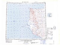 1965 Point Hope1965 Print · USGSCoastal North Slope Alaska is captured in the mid-1960s, showing the intersection of remote settlements and military-era infrastructure. Genealogists and historians can trace the Winter Trail, the remains of Jabbertown, and numerous historical sites like Kukpuk.
End of results
Showing maps 1-4 of 4
Frequently asked questions
- What are the different types of historical maps available for Point Hope?
- What is the oldest map of Point Hope?
- Where can I purchase historical maps of Point Hope for my home or office?
- Where can I download high-res historical maps of Point Hope?
- Are there historical topographic maps available for Point Hope?
- Is there historical aerial imagery available for Point Hope?
- Where are historical maps of Point Hope sourced from?