Old Maps of Prudhoe Bay, Alaska for Hiking & Exploration
Hike through history with 7 historic maps of Prudhoe Bay. Explore old trails, ghost towns, and forgotten backroads — perfect for outdoor adventurers and local explorers.
- Rediscover forgotten places: Map out old mining camps, roads, and footpaths that no longer exist on modern maps.
- Layer with modern tools: Combine with LiDAR or satellite views to plan hikes through historical terrain.
- Made for exploration: Popular among hikers, overlanders, and local history lovers.
Use these maps to find adventure and explore the hidden past of Prudhoe Bay.
Prudhoe Bay, AK maps
(7)- 1951 Map of Beechey Point
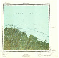
 1951 Beechey Point1951 Print · USGSThe North Slope coast is captured here just after the war, showing the wild river deltas and barrier islands of the Arctic. Trace the natural flow of the Sagavanirktok River and locate coastal landmarks like Beechey Point and Prudhoe Bay before their industrial transformation.
 - 1955 Map of Beechey Point, 1961 Print
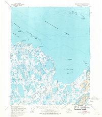
 1955 Beechey Point1961 Print · USGSThe Arctic coastline of the North Slope appears here in the mid-fifties, years before industrial oil development reshaped the landscape. Researchers can trace the original paths of the Kuparuk River and Sagavanirktok River or locate coastal outposts like Beechey Point and remote cabins.5 unique versions available
 - 1955 Map of Beechey Point B-3, 1969 Print
 1955 Beechey Point B-31969 Print · USGSThe North Slope coastline in the mid-fifties remains a remote wilderness of islands and rivers before the oil era. Trace the natural delta of the Sagavanirktok River and locate seasonal cabins near Point McIntyre.2 unique versions available
 - 1960 Map of Beechey Point, 1977 Print
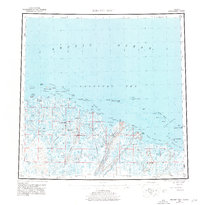 1960 Beechey Point1977 Print · USGSThe Alaska North Slope emerges in this mid-century survey as industrial infrastructure begins to take hold along the Arctic coast. Researchers can trace early developments at Deadhorse and Prudhoe Bay or locate remote coastal points like Beechey Point.3 unique versions available
 - 1964 Map of Beechey Point
 1964 Beechey Point1964 Print · USGSThe North Slope coast and Prudhoe Bay are documented in the mid-sixties, years before the regional oil boom. Researchers can trace the original paths of the Sagavanirktok River and Kuparik River or locate remote coastal cabins and the McClure Islands.
 - 1970 Map of Beechey Point B-3 SW, 1971 Print
 1970 Beechey Point B-3 SW1971 Print · USGSThe North Slope during the early years of the oil boom is revealed here, documenting the initial industrial infrastructure along Prudhoe Bay. Trace the early logistics of the region through Frontier Camp, the Winter Landing Strip, and the historic Discovery Well Prudhoe Bay State No 1.2 unique versions available
 - 2017 Map of Beechey Point B-3 SW, 2017 Print
 2017 Beechey Point B-3 SW2017 Print · USGSThe North Slope coastal plain is captured here in the late twenty-first century, showing the intersection of industrial energy and Arctic waters. Trace the route of the Alaska Pipeline as it traverses the tundra near the Putuligayuk River and Stefansson Sound.
End of results
Showing maps 1-7 of 7
Top cities near Prudhoe Bay
Frequently asked questions
- What are the different types of historical maps available for Prudhoe Bay?
- What is the oldest map of Prudhoe Bay?
- Where can I purchase historical maps of Prudhoe Bay for my home or office?
- Where can I download high-res historical maps of Prudhoe Bay?
- Are there historical topographic maps available for Prudhoe Bay?
- Is there historical aerial imagery available for Prudhoe Bay?
- Where are historical maps of Prudhoe Bay sourced from?