
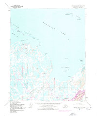
1955 Map of Beechey Point B-3
USGS Topo · Published 1969About this map
The coastal waters of the Beaufort Sea dominate this 1955 survey of the Arctic coastline, just years before large-scale industrial development would transform the region. The landscape is defined by the sweeping Prudhoe Bay and the intricate drainage of the Sagavanirktok River and Putuligayuk River as they meet the shoreline. A series of barrier formations, including the Return Islands, Midway Islands, and Stump Island, provide a buffer for Gwydyr Bay against the open sea. Inland, the terrain is a dense network of lakes and marshes, punctuated by few landmarks like the Prudhoe Mound. Evidence of early human presence is sparse but specific, with cabins noted near Point McIntyre and a remote Landing Strip near the delta, reflecting the seasonal and scientific activity characteristic of the North Slope in the mid-20th century.
Find a feature on this map
21 named features on this map. Tap any name to fly to it.
Don’t see what you’re looking for? This feature index may not catch every label — zoom into the map to look around manually.
Map Details
Editions of this 1955 Beechey Point B-3 Map
2 editions found
Other maps of this area

1951 · Beechey Point
USGS Topo · 1:250,000

1955 · Beechey Point
USGS Topo · 1:250,000

1955 · Beechey Point B-2
USGS Topo · 1:63,360
1955 · Beechey Point C-4
USGS Topo · 1:63,360

1955 · Beechey Point B-4
USGS Topo · 1:63,360

1955 · Beechey Point A-2
USGS Topo · 1:63,360

1955 · Beechey Point A-3
USGS Topo · 1:63,360

1955 · Beechey Point A-4
USGS Topo · 1:63,360

1960 · Beechey Point
USGS Topo · 1:250,000

1962 · Beechey Point B-2
USGS Topo · 1:50,000