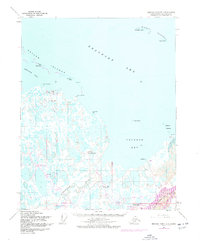
1955 Map of Beechey Point B-3
USGS Topo · Published 1977About this map
Prudhoe Bay and the frozen shoreline of the Beaufort Sea define this landscape during a transformative period of Arctic exploration. While the original 1955 survey captures the raw coastal topography, the 1975 revisions reveal the massive industrial footprint of the oil boom. The map documents the early infrastructure of the North Slope, including the Discovery Well Prudhoe Bay State No 1 and North Prudhoe State 1. A network of pumping stations and the primary Pipeline now cross the tundra, connecting Base Camp and Point Storkersen Camp to the Prudhoe Dock. The braided channels of the Sagavanirktok River and Putuligayuk River wind through a terrain marked by thousands of small lakes and the distinct Prudhoe Mound.
Find a feature on this map
35 named features on this map. Tap any name to fly to it.
Don’t see what you’re looking for? This feature index may not catch every label — zoom into the map to look around manually.
Map Details
Editions of this 1955 Beechey Point B-3 Map
2 editions found
Other maps of this area

1951 · Beechey Point
USGS Topo · 1:250,000

1955 · Beechey Point
USGS Topo · 1:250,000

1955 · Beechey Point B-2
USGS Topo · 1:63,360
1955 · Beechey Point C-4
USGS Topo · 1:63,360

1955 · Beechey Point B-4
USGS Topo · 1:63,360

1955 · Beechey Point A-2
USGS Topo · 1:63,360

1955 · Beechey Point A-3
USGS Topo · 1:63,360

1955 · Beechey Point A-4
USGS Topo · 1:63,360

1955 · Beechey Point B-3
USGS Topo · 1:63,360

1960 · Beechey Point
USGS Topo · 1:250,000