Old Maps of Utqiaġvik, Alaska for Academic Research
Study the evolution of Utqiaġvik with 12 high-resolution historic maps. Whether you're teaching, researching, or modeling changes in land use, these maps provide essential visual documentation of urban, environmental, and geographic change.
- Analyze long-term change: Track patterns in development, transportation, and natural features.
- Ideal for environmental or urban studies: Support academic projects with primary historical map data.
- Use in the classroom or lab: Educators and researchers rely on these maps to bring historical context to life.
These maps are a powerful tool for teaching, research, and visualizing how Utqiaġvik has changed over the decades.
Utqiaġvik, AK maps
(12)- 1945 Map of Barrow, 1954 Print
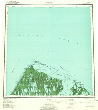
 1945 Barrow1954 Print · USGSThe northernmost tip of Alaska is captured here in the mid-1940s as the region became a focus for naval energy reserves. Researchers can locate the village of Nuwuk, the strategic Barrow Airfield, and the Will Rogers and Wiley Post Memorial.
 - 1949 Map of Barrow
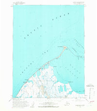
 1949 Barrow1949 Print · USGSThe northernmost edge of the continent is captured in the late 1940s, showing the early infrastructure of the North Slope. Researchers can locate Barrow and Nuwuk, trace the Plover Islands chain, and find the Will Rogers and Wiley Post Memorial.2 unique versions available
 - 1955 Map of Barrow, 1960 Print
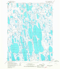
 1955 Barrow1960 Print · USGSThe northernmost edge of the continent is documented here in the mid-1950s, showing the early infrastructure of Barrow and Browerville. You can trace the historic Winter Trail, find the Will Rogers and Wiley Post Memorial, and locate remote sites like Port Moore and the Tapkaluk Islands.8 unique versions available
 - 1955 Map of Barrow B-4, 1966 Print
 1955 Barrow B-41966 Print · USGSThe northernmost tip of Alaska is captured during the mid-fifties, showing the intersection of three Arctic seas at Point Barrow. Researchers can trace early settlements and infrastructure like Nuwuk, Browerville, and the Pt Barrow Airfield at the edge of Elson Lagoon.2 unique versions available
 - 1955 Map of Barrow A-4, 1967 Print
 1955 Barrow A-41967 Print · USGSThe North Slope of Alaska in the mid-fifties reveals a remote landscape of thaw lakes and early petroleum exploration trails. Researchers can trace historic access routes via the Tractor Trail or locate early industrial sites like Gas Well No 3 (Abandoned).2 unique versions available
 - 1955 Map of Barrow A-5, 1967 Print
 1955 Barrow A-51967 Print · USGSThe Arctic coastline near Barrow appears here in the mid-1950s, a landscape of seasonal trails and specialized navigation outposts. You can locate the Will Rogers and Wiley Post Memorial and trace the shore from Nulavik to Walakpa Bay.3 unique versions available
 - 1962 Map of Barrow B-4
 1962 Barrow B-41962 Print · USGSThe Arctic coast at the northernmost tip of Alaska is captured here in the early sixties, showing the vital infrastructure of the North Slope. Researchers can trace the development of Barrow and Nuwuk alongside energy exploration markers like Gas Well No 4.
 - 1962 Map of Barrow A-4
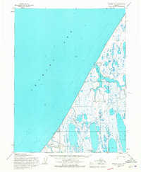
 1962 Barrow A-41962 Print · USGSThe North Slope during the early sixties was a landscape of strategic energy scouting and vast tundra lakes. Researchers can trace the early industrial footprint of the Naval Petroleum Reserve No 4 and locate sites like Gas well No 3 (abandoned).
 - 1973 Map of Barrow B-4, 1977 Print
 1973 Barrow B-41977 Print · USGSThe northern tip of Alaska is captured here in the early seventies, detailing the intersection of scientific research and Arctic settlement. Researchers can trace the layout of Barrow, the Naval Arctic Research Laboratory, and the remote Nuwuk site at the very edge of the continent.
 - 2020 Map of Barrow B-4 SW, 2020 Print
 2020 Barrow B-4 SW2020 Print · USGSCoastal life in the northernmost reaches of Alaska is captured here in the communities of Utqiaġvik and Browerville. Researchers can trace the layout of the arctic town from Stevenson Street to the Imaiqsun Cem and the Wiley Post-Will Rogers Memorial Airport.
 - 2020 Map of Barrow A-5 NE, 2020 Print
 2020 Barrow A-5 NE2020 Print · USGSThe Arctic coastline of the North Slope is captured here in the 2020s, showing where the tundra meets the sea. Map researchers can trace the coastal contours from Point Shadden to the waters of Walakpa Bay near Utqiaġvik.
 - 2020 Map of Barrow A-4 NW, 2020 Print
 2020 Barrow A-4 NW2020 Print · USGSThe Arctic coastal plain near Utqiaġvik is captured here in its modern state, showing a landscape dominated by permafrost and thaw lakes. Researchers can trace the massive basins of Ikroavik Lake and Pingoakeok Lake across this unique North Slope terrain.
End of results
Showing maps 1-12 of 12
Top neighborhoods of Utqiaġvik
Frequently asked questions
- What are the different types of historical maps available for Utqiaġvik?
- What is the oldest map of Utqiaġvik?
- Where can I purchase historical maps of Utqiaġvik for my home or office?
- Where can I download high-res historical maps of Utqiaġvik?
- Are there historical topographic maps available for Utqiaġvik?
- Is there historical aerial imagery available for Utqiaġvik?
- Where are historical maps of Utqiaġvik sourced from?