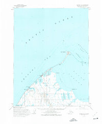
1973 Map of Barrow B-4
USGS Topo · Published 1977About this map
Point Barrow marks the northernmost tip of this survey, where the Arctic Ocean meets the Chukchi Sea and Beaufort Sea. The landscape is dominated by complex hydrology, including the vast Elson Lagoon and numerous thermokarst bodies like Footprint Lake and Imikpuk Lake. Infrastructure focused on scientific and military presence is evident at the Naval Arctic Research Laboratory and the Air Force Radar Site. Settlement patterns are concentrated at Barrow and Browerville, supported by the Wiley Post - Will Rogers Memorial Airport. Inland, a network of tractor trails and winter trails connect remote resource points such as Gas Well No 4 and the Avak Test Hole, illustrating the logistical challenges of Arctic operations in the mid-20th century.
Find a feature on this map
40 named features on this map. Tap any name to fly to it.
Don’t see what you’re looking for? This feature index may not catch every label — zoom into the map to look around manually.
Map Details
Editions of this 1973 Barrow B-4 Map
This is the sole edition of this map. No revisions or reprints were ever made.
Other maps of this area

1945 · Barrow
USGS Topo · 1:250,000

1949 · Barrow
USGS Topo · 1:250,000

1955 · Barrow
USGS Topo · 1:250,000

1955 · Barrow B-4
USGS Topo · 1:63,360

1955 · Barrow A-4
USGS Topo · 1:63,360

1955 · Barrow A-5
USGS Topo · 1:63,360

1955 · Barrow A-3
USGS Topo · 1:63,360
1955 · Barrow B-3
USGS Topo · 1:63,360
1962 · Barrow B-4
USGS Topo · 1:50,000
1962 · Barrow A-4
USGS Topo · 1:50,000