
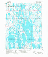
1955 Map of Barrow A-4
USGS Topo · Published 1967About this map
Sungovak Lake and Sukok Lake dominate this 1955 landscape of the Arctic coastal plain within Naval Petroleum Reserve No. 4. The area is defined by its complex hydrography, featuring numerous elongated thermokarst lakes such as Evrulivik Lake and Kimouksik Lake, which reflect the region's permafrost-driven geography. Early industrial exploration is evidenced by Gas Well No 3 (Abandoned) and a sparse network of Tractor Trails that provided the only overland access across the marshy tundra. From the shores of Nunavak Bay to the inland waters of Ikroavik Lake, the map captures a period of government-led resource assessment and mapping in the Alaskan wilderness before more modern infrastructure arrived.
Find a feature on this map
13 named features on this map. Tap any name to fly to it.
Don’t see what you’re looking for? This feature index may not catch every label — zoom into the map to look around manually.
Map Details
Editions of this 1955 Barrow A-4 Map
2 editions found
Other maps of this area

1945 · Barrow
USGS Topo · 1:250,000

1949 · Barrow
USGS Topo · 1:250,000

1951 · Meade River
USGS Topo · 1:250,000

1955 · Barrow
USGS Topo · 1:250,000

1955 · Barrow B-4
USGS Topo · 1:63,360

1955 · Meade River
USGS Topo · 1:250,000

1955 · Barrow A-5
USGS Topo · 1:63,360

1955 · Barrow A-3
USGS Topo · 1:63,360

1955 · Meade River D-2
USGS Topo · 1:63,360
1955 · Barrow B-3
USGS Topo · 1:63,360