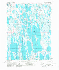
1955 Map of Barrow A-4
USGS Topo · Published 1980About this map
Ikroavik Lake and a series of elongated, north-south oriented water bodies dominate this Arctic coastal landscape south of the Barrow Corporate Boundary. This mid-century survey by the Army Map Service reveals an early phase of energy exploration in the National Petroleum Reserve, evidenced by Gas Well No 12, Gas Well No 14, and the Gas Well No 30 (Abandoned). The terrain is defined by its complex hydrology, featuring Sungovak Lake, Kimouksik Lake, and Evrulivik Lake.
Find a feature on this map
14 named features on this map. Tap any name to fly to it.
Don’t see what you’re looking for? This feature index may not catch every label — zoom into the map to look around manually.
Map Details
Editions of this 1955 Barrow A-4 Map
2 editions found
Other maps of this area

1945 · Barrow
USGS Topo · 1:250,000

1949 · Barrow
USGS Topo · 1:250,000

1951 · Meade River
USGS Topo · 1:250,000

1955 · Barrow
USGS Topo · 1:250,000

1955 · Barrow B-4
USGS Topo · 1:63,360

1955 · Meade River
USGS Topo · 1:250,000

1955 · Barrow A-4
USGS Topo · 1:63,360

1955 · Barrow A-5
USGS Topo · 1:63,360

1955 · Barrow A-3
USGS Topo · 1:63,360

1955 · Meade River D-2
USGS Topo · 1:63,360