
1955 Map of Meade River D-2
USGS Topo · Published 1967About this map
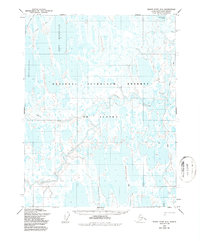
The Inaru River meanders across this Arctic landscape, defining the hydrology of a region dominated by thaw lakes and coastal plain tundra. Mapped in the mid-1950s within the boundaries of the Naval Petroleum Reserve No. 4, the sheet reveals a remote wilderness where transport was limited to a few specific Tractor routes and a seasonal Trail. Large water bodies like Kilusiktok Lake and Eyrulivik Lake are prominent landmarks in a terrain otherwise saturated with unnamed ponds. A lone Cabin near the river bank serves as the only evidence of human habitation, likely used for trapping or seasonal subsistence. This survey, compiled from photogrammetric methods by the Army Map Service and the Bureau of Land Management, captures the area's geography before significant modern development in the North Slope region.
Find a feature on this map
14 named features on this map. Tap any name to fly to it.
Don’t see what you’re looking for? This feature index may not catch every label — zoom into the map to look around manually.
Map Details
Editions of this 1955 Meade River D-2 Map
2 editions found
Other maps of this area

1945 · Barrow
USGS Topo · 1:250,000

1949 · Barrow
USGS Topo · 1:250,000

1951 · Meade River
USGS Topo · 1:250,000

1955 · Barrow
USGS Topo · 1:250,000

1955 · Meade River
USGS Topo · 1:250,000

1955 · Barrow A-4
USGS Topo · 1:63,360

1955 · Barrow A-5
USGS Topo · 1:63,360

1955 · Meade River C-1
USGS Topo · 1:63,360

1955 · Meade River C-3
USGS Topo · 1:63,360

1955 · Meade River D-3
USGS Topo · 1:63,360