1900s (20th Century) Maps of Buckland, Alaska
Explore 4 historic maps of Buckland from the 1900s (20th Century). These maps offer a rare glimpse into what life looked like during the 1900s — showing old roads, neighborhoods, homes, and landmarks that have changed or disappeared over time.
Whether you're researching your family's past, planning a metal detecting trip, or studying how Buckland's landscape evolved across the 1900s, these high-resolution maps are a powerful tool for exploring the history of this region.
- Focus on a specific era: All maps on this page are from the 1900s, giving you a focused view of this time period.
- See what’s changed: Compare century-old streets, trails, and buildings to today's modern landscape using overlays and satellite layers.
- Research with precision: Use these maps for genealogy, historical research, land use analysis, or educational projects.
- View, download, or print: Maps are fully viewable online in high resolution, and can be downloaded or printed for your own records.
Start exploring Buckland's history through authentic maps from the 1900s. This is your window into the past.
Buckland, AK maps
(4)- 1951 Map of Candle
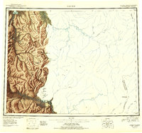 1951 Candle1951 Print · USGSThe gold-producing drainages of the Seward Peninsula are shown here in the early 1950s, a landscape defined by hydraulic mining and aviation. Genealogists and historians can trace remote outposts like Snyder Roadhouse, the mining hub of Candle, and the Candle Ditch.3 unique versions available
 - 1951 Map of Candle D-5, 1957 Print
 1951 Candle D-51957 Print · USGSIn the Alaskan wilderness during the early fifties, this area shows a landscape defined by its river networks and high peaks. Genealogists and historians can trace routes along the Tractor Trail or locate the remote Cabin near Sugar Top and Clem Mountain.3 unique versions available
 - 1955 Map of Candle, 1961 Print
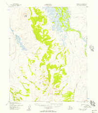
 1955 Candle1961 Print · USGSNorthwest Alaska in the mid-fifties reveals a landscape of remote settlements and aviation outposts connected by river systems. Researchers can trace the early infrastructure of Candle, the Reindeer Corral near Buckland, and old mining works along Gold Run.6 unique versions available
 - 1964 Map of Candle
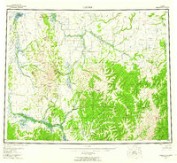
 1964 Candle1964 Print · USGSRemote outposts and gold-bearing creeks mark the Northwest Arctic during the mid-1960s, a time of transition for the Seward Peninsula. You can trace early overland travel along the Tractor Trail or locate vanished mining sites at Haycock and Dime Landing.
End of results
Showing maps 1-4 of 4
Frequently asked questions
- What are the different types of historical maps available for Buckland?
- What is the oldest map of Buckland?
- Where can I purchase historical maps of Buckland for my home or office?
- Where can I download high-res historical maps of Buckland?
- Are there historical topographic maps available for Buckland?
- Is there historical aerial imagery available for Buckland?
- Where are historical maps of Buckland sourced from?