Old Maps of Buckland, Alaska for Academic Research
Study the evolution of Buckland with 5 high-resolution historic maps. Whether you're teaching, researching, or modeling changes in land use, these maps provide essential visual documentation of urban, environmental, and geographic change.
- Analyze long-term change: Track patterns in development, transportation, and natural features.
- Ideal for environmental or urban studies: Support academic projects with primary historical map data.
- Use in the classroom or lab: Educators and researchers rely on these maps to bring historical context to life.
These maps are a powerful tool for teaching, research, and visualizing how Buckland has changed over the decades.
Buckland, AK maps
(5)- 1951 Map of Candle
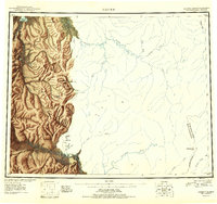 1951 Candle1951 Print · USGSThe gold-producing drainages of the Seward Peninsula are shown here in the early 1950s, a landscape defined by hydraulic mining and aviation. Genealogists and historians can trace remote outposts like Snyder Roadhouse, the mining hub of Candle, and the Candle Ditch.3 unique versions available
 - 1951 Map of Candle D-5, 1957 Print
 1951 Candle D-51957 Print · USGSIn the Alaskan wilderness during the early fifties, this area shows a landscape defined by its river networks and high peaks. Genealogists and historians can trace routes along the Tractor Trail or locate the remote Cabin near Sugar Top and Clem Mountain.3 unique versions available
 - 1955 Map of Candle, 1961 Print
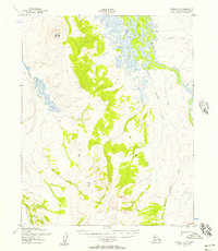
 1955 Candle1961 Print · USGSNorthwest Alaska in the mid-fifties reveals a landscape of remote settlements and aviation outposts connected by river systems. Researchers can trace the early infrastructure of Candle, the Reindeer Corral near Buckland, and old mining works along Gold Run.6 unique versions available
 - 1964 Map of Candle
 1964 Candle1964 Print · USGSRemote outposts and gold-bearing creeks mark the Northwest Arctic during the mid-1960s, a time of transition for the Seward Peninsula. You can trace early overland travel along the Tractor Trail or locate vanished mining sites at Haycock and Dime Landing.
 - 2014 Map of Candle D-5 NE, 2014 Print
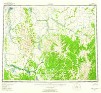
 2014 Candle D-5 NE2014 Print · USGSThe village of Buckland and its surrounding tundra are captured here in the early twenty-first century. Researchers can trace the local infrastructure from the Buckland Airport to the PO, while following the winding course of the Buckland River.
End of results
Showing maps 1-5 of 5
Frequently asked questions
- What are the different types of historical maps available for Buckland?
- What is the oldest map of Buckland?
- Where can I purchase historical maps of Buckland for my home or office?
- Where can I download high-res historical maps of Buckland?
- Are there historical topographic maps available for Buckland?
- Is there historical aerial imagery available for Buckland?
- Where are historical maps of Buckland sourced from?