Old Maps of Candle, Alaska for Metal Detecting
Plan your next treasure hunt with 5 historic maps of Candle. Find old homesites, ghost towns, trails, and gathering spots that may be lost to time — perfect for identifying promising metal detecting locations.
- Locate forgotten sites: Uncover places like long-lost settlements, abandoned rail lines, or gathering spots.
- Plan better hunts: Use map overlays combined with LiDAR or satellite views to narrow in on historically rich areas.
- Made for detectorists: Thousands of hobbyists use these maps to discover relics, coins, and hidden history.
Use these historic maps to boost your research and find new opportunities beneath the surface of Candle.
Candle, AK maps
(5)- 1951 Map of Candle
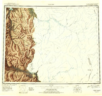 1951 Candle1951 Print · USGSThe gold-producing drainages of the Seward Peninsula are shown here in the early 1950s, a landscape defined by hydraulic mining and aviation. Genealogists and historians can trace remote outposts like Snyder Roadhouse, the mining hub of Candle, and the Candle Ditch.3 unique versions available
 - 1951 Map of Candle D-6, 1957 Print
 1951 Candle D-61957 Print · USGSThe mining outpost of Candle served as a vital hub in the Alaskan bush during the early fifties, accessible only by air and seasonal paths. Researchers can trace the industrial footprint of the era through Mine Tailings, a Pipeline, and the Winter Trail winding along the Kiwalik River.3 unique versions available
 - 1955 Map of Candle, 1961 Print
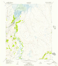
 1955 Candle1961 Print · USGSNorthwest Alaska in the mid-fifties reveals a landscape of remote settlements and aviation outposts connected by river systems. Researchers can trace the early infrastructure of Candle, the Reindeer Corral near Buckland, and old mining works along Gold Run.6 unique versions available
 - 1964 Map of Candle
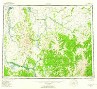
 1964 Candle1964 Print · USGSRemote outposts and gold-bearing creeks mark the Northwest Arctic during the mid-1960s, a time of transition for the Seward Peninsula. You can trace early overland travel along the Tractor Trail or locate vanished mining sites at Haycock and Dime Landing.
 - 2017 Map of Candle D-6 NW, 2017 Print
 2017 Candle D-6 NW2017 Print · USGSThe Seward Peninsula town of Candle and its surrounding tundra are captured here in the early twenty-first century. Researchers can trace the winding Kiwalik River as it reaches toward Kotzebue Sound and locate the remote Candle 2 Airport.
End of results
Showing maps 1-5 of 5
Frequently asked questions
- What are the different types of historical maps available for Candle?
- What is the oldest map of Candle?
- Where can I purchase historical maps of Candle for my home or office?
- Where can I download high-res historical maps of Candle?
- Are there historical topographic maps available for Candle?
- Is there historical aerial imagery available for Candle?
- Where are historical maps of Candle sourced from?