1950s Maps of Espenberg, Alaska
Explore 3 historic maps of Espenberg from the 1950s. These maps offer a rare glimpse into what life looked like during the 1950s — showing old roads, neighborhoods, homes, and landmarks that have changed or disappeared over time.
Whether you're researching your family's past, planning a metal detecting trip, or studying how Espenberg's landscape evolved across the 1950s, these high-resolution maps are a powerful tool for exploring the history of this region.
- Focus on a specific era: All maps on this page are from the 1950s, giving you a focused view of this time period.
- See what’s changed: Compare century-old streets, trails, and buildings to today's modern landscape using overlays and satellite layers.
- Research with precision: Use these maps for genealogy, historical research, land use analysis, or educational projects.
- View, download, or print: Maps are fully viewable online in high resolution, and can be downloaded or printed for your own records.
Start exploring Espenberg's history through authentic maps from the 1950s. This is your window into the past.
Espenberg, AK maps
(3)- 1950 Map of Kotzebue C-4, 1957 Print
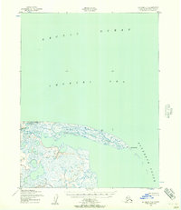 1950 Kotzebue C-41957 Print · USGSThe Arctic coast of Alaska meets the sea at the turn of the 1950s in this detailed topographic study. Researchers can trace the shifting sands of Cape Espenberg and the mouth of the Espenberg River where it enters the Chukchi Sea.2 unique versions available
 - 1951 Map of Kotzebue
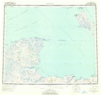 1951 Kotzebue1951 Print · USGSNorthwestern Alaska at the start of the 1950s reveals a landscape defined by the Baldwin Peninsula and coastal outposts. Researchers can trace the Winter Trail and locate sites like Deering, Espenberg, and the Landplane Airport.5 unique versions available
 - 1958 Map of Kotzebue
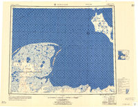 1958 Kotzebue1958 Print · USGSThe Arctic coastline and the northern edge of the Seward Peninsula are captured here during the late fifties. Researchers can trace early aviation and maritime sites, from the Commercial Airport at Kotzebue to the remote cabins along the Serpentine River.
End of results
Showing maps 1-3 of 3
Frequently asked questions
- What are the different types of historical maps available for Espenberg?
- What is the oldest map of Espenberg?
- Where can I purchase historical maps of Espenberg for my home or office?
- Where can I download high-res historical maps of Espenberg?
- Are there historical topographic maps available for Espenberg?
- Is there historical aerial imagery available for Espenberg?
- Where are historical maps of Espenberg sourced from?