Old Maps of Espenberg, Alaska for Academic Research
Study the evolution of Espenberg with 5 high-resolution historic maps. Whether you're teaching, researching, or modeling changes in land use, these maps provide essential visual documentation of urban, environmental, and geographic change.
- Analyze long-term change: Track patterns in development, transportation, and natural features.
- Ideal for environmental or urban studies: Support academic projects with primary historical map data.
- Use in the classroom or lab: Educators and researchers rely on these maps to bring historical context to life.
These maps are a powerful tool for teaching, research, and visualizing how Espenberg has changed over the decades.
Espenberg, AK maps
(5)- 1950 Map of Kotzebue C-4, 1957 Print
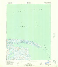 1950 Kotzebue C-41957 Print · USGSThe Arctic coast of Alaska meets the sea at the turn of the 1950s in this detailed topographic study. Researchers can trace the shifting sands of Cape Espenberg and the mouth of the Espenberg River where it enters the Chukchi Sea.2 unique versions available
 - 1951 Map of Kotzebue
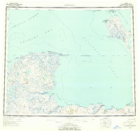 1951 Kotzebue1951 Print · USGSNorthwestern Alaska at the start of the 1950s reveals a landscape defined by the Baldwin Peninsula and coastal outposts. Researchers can trace the Winter Trail and locate sites like Deering, Espenberg, and the Landplane Airport.5 unique versions available
 - 1958 Map of Kotzebue
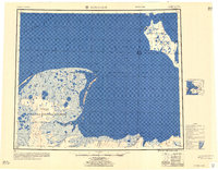 1958 Kotzebue1958 Print · USGSThe Arctic coastline and the northern edge of the Seward Peninsula are captured here during the late fifties. Researchers can trace early aviation and maritime sites, from the Commercial Airport at Kotzebue to the remote cabins along the Serpentine River.
 - 1964 Map of Kotzebue
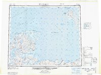 1964 Kotzebue1964 Print · USGSThe Northwest Arctic coast during the mid-sixties reveals a landscape of isolated seasonal trails and maritime outposts. Researchers can trace the Winter Trail across the tundra to settlements like Deering, Kotzebue, and Singreak.
 - 2014 Map of Kotzebue C-4 SW, 2014 Print
 2014 Kotzebue C-4 SW2014 Print · USGSThe Seward Peninsula shoreline meets the Arctic waters of the Chukchi Sea in this 2014 coastal survey. Researchers can trace the wetlands of the Bering Land Bridge National Preserve and the isolated settlement of Espenberg.
End of results
Showing maps 1-5 of 5
Frequently asked questions
- What are the different types of historical maps available for Espenberg?
- What is the oldest map of Espenberg?
- Where can I purchase historical maps of Espenberg for my home or office?
- Where can I download high-res historical maps of Espenberg?
- Are there historical topographic maps available for Espenberg?
- Is there historical aerial imagery available for Espenberg?
- Where are historical maps of Espenberg sourced from?