Old Maps of Kiwalik, Alaska for Academic Research
Study the evolution of Kiwalik with 4 high-resolution historic maps. Whether you're teaching, researching, or modeling changes in land use, these maps provide essential visual documentation of urban, environmental, and geographic change.
- Analyze long-term change: Track patterns in development, transportation, and natural features.
- Ideal for environmental or urban studies: Support academic projects with primary historical map data.
- Use in the classroom or lab: Educators and researchers rely on these maps to bring historical context to life.
These maps are a powerful tool for teaching, research, and visualizing how Kiwalik has changed over the decades.
Kiwalik, AK maps
(4)- 1951 Map of Selawik
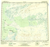 1951 Selawik1951 Print · USGSThe Arctic landscape of the early 1950s unfolds across this survey of the Kobuk River delta and the vast inland waters. Researchers can trace remote outposts and infrastructure like the Okok Trading Post, Reindeer Station, and several Winter Trails.
 - 1951 Map of Selawik A-6, 1967 Print
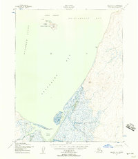 1951 Selawik A-61967 Print · USGSThe Arctic coastline of Northwest Alaska in the early fifties is defined here by the confluence of the Chukchi Sea and the Kiwalik settlement. Researchers can trace the maritime geography of Chamisso National Wildlife Refuge and find the remote Airstrip at Kiwalik Lagoon.2 unique versions available
 - 1957 Map of Selawik, 1961 Print
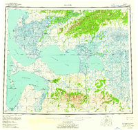 1957 Selawik1961 Print · USGSNorthwest Arctic Alaska in the late fifties reveals a vast network of delta channels and isolated outposts above the Arctic Circle. Genealogists and historians can trace traditional locations like Noorvik and Kiana or remote landmarks such as the Reindeer Corral Cabin.7 unique versions available
 - 2017 Map of Selawik A-6 SW, 2017 Print
 2017 Selawik A-6 SW2017 Print · USGSThe southern shores of Kotzebue Sound are captured here in the early twenty-first century, showing the remote coastal settlement of Kiwalik. Researchers can trace the winding paths of Minnehaha Creek and Kirk Creek as they feed into Kiwalik Lagoon.
End of results
Showing maps 1-4 of 4
Frequently asked questions
- What are the different types of historical maps available for Kiwalik?
- What is the oldest map of Kiwalik?
- Where can I purchase historical maps of Kiwalik for my home or office?
- Where can I download high-res historical maps of Kiwalik?
- Are there historical topographic maps available for Kiwalik?
- Is there historical aerial imagery available for Kiwalik?
- Where are historical maps of Kiwalik sourced from?