Old Maps of Kiwalik, Alaska for Genealogy
Trace your family roots with 4 historic maps of Kiwalik. These high-res maps reveal old neighborhoods, homesites, landmarks, and streets — helping you uncover where your ancestors lived and how the area evolved over time.
- Explore historic neighborhoods: Identify where your relatives may have lived in the 1800s or 1900s.
- Compare maps over time: Trace the changes in streets, buildings, and landmarks for multi-generational research.
- Perfect for genealogy & ancestry research: Used by family historians and researchers to map out lineage and migration.
These maps are an incredible resource for exploring your personal connection to Kiwalik's past.
Kiwalik, AK maps
(4)- 1951 Map of Selawik
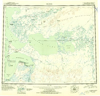 1951 Selawik1951 Print · USGSThe Arctic landscape of the early 1950s unfolds across this survey of the Kobuk River delta and the vast inland waters. Researchers can trace remote outposts and infrastructure like the Okok Trading Post, Reindeer Station, and several Winter Trails.
 - 1951 Map of Selawik A-6, 1967 Print
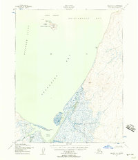 1951 Selawik A-61967 Print · USGSThe Arctic coastline of Northwest Alaska in the early fifties is defined here by the confluence of the Chukchi Sea and the Kiwalik settlement. Researchers can trace the maritime geography of Chamisso National Wildlife Refuge and find the remote Airstrip at Kiwalik Lagoon.2 unique versions available
 - 1957 Map of Selawik, 1961 Print
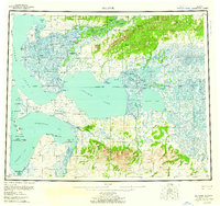 1957 Selawik1961 Print · USGSNorthwest Arctic Alaska in the late fifties reveals a vast network of delta channels and isolated outposts above the Arctic Circle. Genealogists and historians can trace traditional locations like Noorvik and Kiana or remote landmarks such as the Reindeer Corral Cabin.7 unique versions available
 - 2017 Map of Selawik A-6 SW, 2017 Print
 2017 Selawik A-6 SW2017 Print · USGSThe southern shores of Kotzebue Sound are captured here in the early twenty-first century, showing the remote coastal settlement of Kiwalik. Researchers can trace the winding paths of Minnehaha Creek and Kirk Creek as they feed into Kiwalik Lagoon.
End of results
Showing maps 1-4 of 4
Frequently asked questions
- What are the different types of historical maps available for Kiwalik?
- What is the oldest map of Kiwalik?
- Where can I purchase historical maps of Kiwalik for my home or office?
- Where can I download high-res historical maps of Kiwalik?
- Are there historical topographic maps available for Kiwalik?
- Is there historical aerial imagery available for Kiwalik?
- Where are historical maps of Kiwalik sourced from?