1950s Maps of Red Dog Mine, Alaska
Explore 3 historic maps of Red Dog Mine from the 1950s. These maps offer a rare glimpse into what life looked like during the 1950s — showing old roads, neighborhoods, homes, and landmarks that have changed or disappeared over time.
Whether you're researching your family's past, planning a metal detecting trip, or studying how Red Dog Mine's landscape evolved across the 1950s, these high-resolution maps are a powerful tool for exploring the history of this region.
- Focus on a specific era: All maps on this page are from the 1950s, giving you a focused view of this time period.
- See what’s changed: Compare century-old streets, trails, and buildings to today's modern landscape using overlays and satellite layers.
- Research with precision: Use these maps for genealogy, historical research, land use analysis, or educational projects.
- View, download, or print: Maps are fully viewable online in high resolution, and can be downloaded or printed for your own records.
Start exploring Red Dog Mine's history through authentic maps from the 1950s. This is your window into the past.
Red Dog Mine, AK maps
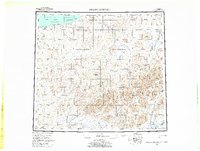
(3)- 1951 Map of De Long Mountains
 1951 De Long Mountains1951 Print · USGSThe Arctic coast and Brooks Range appear in this early postwar survey as a landscape of massive river systems and unnamed peaks. Researchers can trace the path of the Winter Trail near Cape Sabine or locate the remote Thetis Mine and Igloo Mtn.
 - 1955 Map of De Long Mountains, 1964 Print
 1955 De Long Mountains1964 Print · USGSNorth Slope wilderness and the western Brooks Range are captured in the mid-fifties, detailing an era of remote Arctic exploration. Trace the Winter Trail and drainage systems like the Pitmegea River or find landmarks like Cape Sabine.5 unique versions available
 - 1955 Map of De Long Mountains A-2, 1967 Print
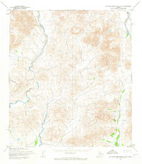 1955 De Long Mountains A-21967 Print · USGSThe De Long Mountains and Brooks Range wilderness appear here in the mid-1950s, a landscape defined entirely by its river systems and peaks. Researchers can trace the sinuous paths of the Wulik River, Ikalukrok Creek, and the heights of Deadlock Mountain.3 unique versions available
End of results
Showing maps 1-3 of 3
Frequently asked questions
- What are the different types of historical maps available for Red Dog Mine?
- What is the oldest map of Red Dog Mine?
- Where can I purchase historical maps of Red Dog Mine for my home or office?
- Where can I download high-res historical maps of Red Dog Mine?
- Are there historical topographic maps available for Red Dog Mine?
- Is there historical aerial imagery available for Red Dog Mine?
- Where are historical maps of Red Dog Mine sourced from?