Old Maps of Red Dog Mine, Alaska for Genealogy
Trace your family roots with 6 historic maps of Red Dog Mine. These high-res maps reveal old neighborhoods, homesites, landmarks, and streets — helping you uncover where your ancestors lived and how the area evolved over time.
- Explore historic neighborhoods: Identify where your relatives may have lived in the 1800s or 1900s.
- Compare maps over time: Trace the changes in streets, buildings, and landmarks for multi-generational research.
- Perfect for genealogy & ancestry research: Used by family historians and researchers to map out lineage and migration.
These maps are an incredible resource for exploring your personal connection to Red Dog Mine's past.
Red Dog Mine, AK maps
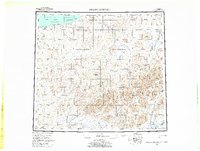
(6)- 1951 Map of De Long Mountains
 1951 De Long Mountains1951 Print · USGSThe Arctic coast and Brooks Range appear in this early postwar survey as a landscape of massive river systems and unnamed peaks. Researchers can trace the path of the Winter Trail near Cape Sabine or locate the remote Thetis Mine and Igloo Mtn.
 - 1955 Map of De Long Mountains, 1964 Print
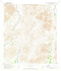
 1955 De Long Mountains1964 Print · USGSNorth Slope wilderness and the western Brooks Range are captured in the mid-fifties, detailing an era of remote Arctic exploration. Trace the Winter Trail and drainage systems like the Pitmegea River or find landmarks like Cape Sabine.5 unique versions available
 - 1955 Map of De Long Mountains A-2, 1967 Print
 1955 De Long Mountains A-21967 Print · USGSThe De Long Mountains and Brooks Range wilderness appear here in the mid-1950s, a landscape defined entirely by its river systems and peaks. Researchers can trace the sinuous paths of the Wulik River, Ikalukrok Creek, and the heights of Deadlock Mountain.3 unique versions available
 - 1965 Map of De Long Mountains
 1965 De Long Mountains1965 Print · USGSThe northern Alaskan wilderness is captured here in the mid-1960s, showing the high peaks of the De Long Mountains and the coastal tundra. Researchers can trace the path of the Winter Trail and locate the Thetis Mine near the Chukchi Sea coastline.
 - 2015 Map of De Long Mountains A-2 SE, 2015 Print
 2015 De Long Mountains A-2 SE2015 Print · USGSCovers Red Dog Mine, including Northwest Arctic, United States, and other nearby areas
 - 2019 Map of De Long Mountains A-2 SE, 2019 Print
 2019 De Long Mountains A-2 SE2019 Print · USGSThe Northwest Arctic tundra meets industrial scale in the De Long Mountains during the late 2010s. Researchers can trace the infrastructure of the Red Dog Mine and its remote Red Dog Airport alongside the Noatak National Preserve.
End of results
Showing maps 1-6 of 6
Frequently asked questions
- What are the different types of historical maps available for Red Dog Mine?
- What is the oldest map of Red Dog Mine?
- Where can I purchase historical maps of Red Dog Mine for my home or office?
- Where can I download high-res historical maps of Red Dog Mine?
- Are there historical topographic maps available for Red Dog Mine?
- Is there historical aerial imagery available for Red Dog Mine?
- Where are historical maps of Red Dog Mine sourced from?