Old Maps of Shungnak, Alaska for Academic Research
Study the evolution of Shungnak with 6 high-resolution historic maps. Whether you're teaching, researching, or modeling changes in land use, these maps provide essential visual documentation of urban, environmental, and geographic change.
- Analyze long-term change: Track patterns in development, transportation, and natural features.
- Ideal for environmental or urban studies: Support academic projects with primary historical map data.
- Use in the classroom or lab: Educators and researchers rely on these maps to bring historical context to life.
These maps are a powerful tool for teaching, research, and visualizing how Shungnak has changed over the decades.
Shungnak, AK maps
(6)- 1951 Map of Shungnak
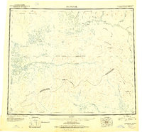 1951 Shungnak1951 Print · USGSNorthwest Alaska was just beginning to be mapped with modern precision in the early fifties, revealing the vast Kobuk and Selawik watersheds. Researchers can trace the riverfront at Shungnak, remote cabins, and high summits like Purcell Mountain.
 - 1955 Map of Shungnak, 1958 Print
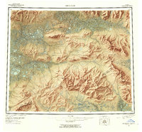 1955 Shungnak1958 Print · USGSUpper Kobuk River life in the mid-fifties centered on the village of Shungnak and the seasonal use of the surrounding wilderness. Researchers can trace remote cabins, old mining sites near Purcell Mtn, and the primitive Landing Area that served this Arctic frontier.6 unique versions available
 - 1955 Map of Shungnak D-3, 1959 Print
 1955 Shungnak D-31959 Print · USGSThe Northwest Arctic interior in the mid-1950s is defined by the winding Kobuk River and its vast network of wetlands. Researchers can locate remote dwellings like Shungnak and various Cabins, or trace the history of the Shungnak Cr Airstrip (Aband).2 unique versions available
 - 1964 Map of Shungnak
 1964 Shungnak1964 Print · USGSNorthwest Alaska in the mid-sixties is mapped here across the wild watersheds of the Kobuk River and Selawik River. Researchers can locate isolated settlements like Shungnak and Kobuk, or trace the path of the Arctic Circle through the Lockwood Hills.
 - 2016 Map of Shungnak D-3 NE, 2016 Print
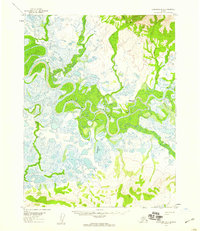
 2016 Shungnak D-3 NE2016 Print · USGSThe village of Shungnak is captured here as it sits along the winding Kobuk River in the Northwest Arctic. Researchers can trace the local street grid, the location of the Shungnak Cem, and the essential Shungnak Airport during this era.
 - 2016 Map of Shungnak D-3 SE, 2016 Print
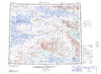
 2016 Shungnak D-3 SE2016 Print · USGSThe Northwest Arctic wilderness is captured here in the mid-2010s, showing a remote landscape defined by the winding Kobuk River. Researchers can trace the path of the Pick River and the isolated waters of Tekeaksakrak Lake amidst the high-relief terrain.
End of results
Showing maps 1-6 of 6
Top cities near Shungnak
Frequently asked questions
- What are the different types of historical maps available for Shungnak?
- What is the oldest map of Shungnak?
- Where can I purchase historical maps of Shungnak for my home or office?
- Where can I download high-res historical maps of Shungnak?
- Are there historical topographic maps available for Shungnak?
- Is there historical aerial imagery available for Shungnak?
- Where are historical maps of Shungnak sourced from?