
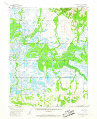
1955 Map of Shungnak D-3
USGS Topo · Published 1959About this map
The meandering Kobuk River dominates this mid-century landscape in the Northwest Arctic, where the settlement of Shungnak serves as the primary focal point. Photogrammetric methods from 1957 reveal a complex network of wetlands and oxbow lakes, with the Kukkeakruk River and Shungnak River feeding into the main channel. The presence of several Cabins and a Sawmill scattered along the waterways suggests a seasonal or subsistence-based economy tied to the river's resources.
Find a feature on this map
13 named features on this map. Tap any name to fly to it.
Don’t see what you’re looking for? This feature index may not catch every label — zoom into the map to look around manually.
Map Details
Editions of this 1955 Shungnak D-3 Map
2 editions found
Other maps of this area

1951 · Shungnak
USGS Topo · 1:250,000

1951 · Ambler River
USGS Topo · 1:250,000

1955 · Shungnak
USGS Topo · 1:250,000

1955 · Ambler River A-4
USGS Topo · 1:63,360

1955 · Shungnak D-4
USGS Topo · 1:63,360

1955 · Shungnak D-2
USGS Topo · 1:63,360

1956 · Ambler River
USGS Topo · 1:250,000

1964 · Shungnak
USGS Topo · 1:250,000

1964 · Ambler River
USGS Topo · 1:250,000
1966 · Ambler River A-4
USGS Topo · 1:63,360