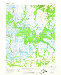
1955 Map of Shungnak D-3
USGS Topo · Published 1967About this map
The Kobuk River dominates this mid-1950s landscape, winding through a complex network of oxbows and wetlands in northern Alaska. The settlement of Shungnak is established on the northern bank, serving as a hub for the region alongside localized industry such as a Sawmill and the Shungnak Landing Strip (Aband). The terrain is defined by the convergence of several major tributaries, including the Shungnak River, the Pick River, and the Kuikcherk River, which cut through a mosaic of tundra and lakes like Tekekakrak Lake. This survey illustrates the reliance on river systems for transportation and subsistence during the mid-twentieth century, with isolated Cabin structures scattered along the shorelines of Garland Creek and Cosmos Creek. The topography transitions from low-lying swampy areas to higher ground as the drainage basins of Warren Creek and Wesley Creek extend toward the northern hills.
Find a feature on this map
16 named features on this map. Tap any name to fly to it.
Don’t see what you’re looking for? This feature index may not catch every label — zoom into the map to look around manually.
Map Details
Editions of this 1955 Shungnak D-3 Map
2 editions found
Other maps of this area

1951 · Shungnak
USGS Topo · 1:250,000

1951 · Ambler River
USGS Topo · 1:250,000

1955 · Shungnak
USGS Topo · 1:250,000

1955 · Ambler River A-4
USGS Topo · 1:63,360

1955 · Shungnak D-4
USGS Topo · 1:63,360

1955 · Shungnak D-2
USGS Topo · 1:63,360

1955 · Shungnak D-3
USGS Topo · 1:63,360

1956 · Ambler River
USGS Topo · 1:250,000

1964 · Shungnak
USGS Topo · 1:250,000

1964 · Ambler River
USGS Topo · 1:250,000