1940s Maps of Kake, Alaska
Explore 2 historic maps of Kake from the 1940s. These maps offer a rare glimpse into what life looked like during the 1940s — showing old roads, neighborhoods, homes, and landmarks that have changed or disappeared over time.
Whether you're researching your family's past, planning a metal detecting trip, or studying how Kake's landscape evolved across the 1940s, these high-resolution maps are a powerful tool for exploring the history of this region.
- Focus on a specific era: All maps on this page are from the 1940s, giving you a focused view of this time period.
- See what’s changed: Compare century-old streets, trails, and buildings to today's modern landscape using overlays and satellite layers.
- Research with precision: Use these maps for genealogy, historical research, land use analysis, or educational projects.
- View, download, or print: Maps are fully viewable online in high resolution, and can be downloaded or printed for your own records.
Start exploring Kake's history through authentic maps from the 1940s. This is your window into the past.
Kake, AK maps
(2)- 1948 Map of Sumdum A-6, 1957 Print
 1948 Sumdum A-61957 Print · USGSKupreanof Island and the surrounding waters of Southeast Alaska are shown here as they appeared in the late 1940s. Researchers can trace the rugged coastline from Pinta Pt to Slate No 2 and locate maritime markers like the Light on Turnabout I.5 unique versions available
 - 1948 Map of Petersburg D-6, 1958 Print
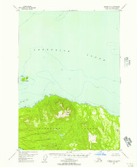
 1948 Petersburg D-61958 Print · USGSKake and the surrounding islands of the Alexander Archipelago are captured here shortly after the war, showing the area's coastal industry and maritime paths. Researchers can trace the Goldstein Trail and locate the historic cannery and Kake settlement.
End of results
Showing maps 1-2 of 2
Frequently asked questions
- What are the different types of historical maps available for Kake?
- What is the oldest map of Kake?
- Where can I purchase historical maps of Kake for my home or office?
- Where can I download high-res historical maps of Kake?
- Are there historical topographic maps available for Kake?
- Is there historical aerial imagery available for Kake?
- Where are historical maps of Kake sourced from?