1950s Maps of Kake, Alaska
Explore 3 historic maps of Kake from the 1950s. These maps offer a rare glimpse into what life looked like during the 1950s — showing old roads, neighborhoods, homes, and landmarks that have changed or disappeared over time.
Whether you're researching your family's past, planning a metal detecting trip, or studying how Kake's landscape evolved across the 1950s, these high-resolution maps are a powerful tool for exploring the history of this region.
- Focus on a specific era: All maps on this page are from the 1950s, giving you a focused view of this time period.
- See what’s changed: Compare century-old streets, trails, and buildings to today's modern landscape using overlays and satellite layers.
- Research with precision: Use these maps for genealogy, historical research, land use analysis, or educational projects.
- View, download, or print: Maps are fully viewable online in high resolution, and can be downloaded or printed for your own records.
Start exploring Kake's history through authentic maps from the 1950s. This is your window into the past.
Kake, AK maps
(3)- 1951 Map of Petersburg D-6, 1964 Print
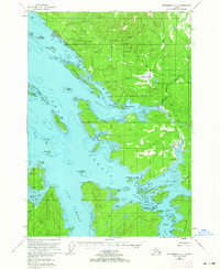 1951 Petersburg D-61964 Print · USGSSoutheast Alaskan island life in the early fifties is defined here by the coastal settlement of Kake and its neighboring waters. Researchers can trace historic paths like the Goldstein Trail and locate early industry at the Cannery on the edge of KUPREANOF ISLAND.3 unique versions available
 - 1952 Map of Petersburg, 1953 Print
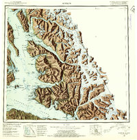
 1952 Petersburg1953 Print · USGSSoutheast Alaska's intricate Alexander Archipelago comes to life in the early fifties, documenting a landscape of remote island settlements and maritime corridors. Genealogists and historians can trace coastal life in Petersburg and Wrangell, or locate early industry at Shakan and regional Mines.5 unique versions available
 - 1952 Map of Sumdum, 1953 Print
 1952 Sumdum1953 Print · USGSSoutheast Alaska in the early fifties was a land of tidewater glaciers and isolated mining outposts. Researchers can trace the layout of remote coastal settlements like Windham and Sumdum or locate the historic Chuck Mining Camp near Endicott Arm.6 unique versions available
End of results
Showing maps 1-3 of 3
Frequently asked questions
- What are the different types of historical maps available for Kake?
- What is the oldest map of Kake?
- Where can I purchase historical maps of Kake for my home or office?
- Where can I download high-res historical maps of Kake?
- Are there historical topographic maps available for Kake?
- Is there historical aerial imagery available for Kake?
- Where are historical maps of Kake sourced from?