Old Maps of Kake, Alaska for Genealogy
Trace your family roots with 13 historic maps of Kake. These high-res maps reveal old neighborhoods, homesites, landmarks, and streets — helping you uncover where your ancestors lived and how the area evolved over time.
- Explore historic neighborhoods: Identify where your relatives may have lived in the 1800s or 1900s.
- Compare maps over time: Trace the changes in streets, buildings, and landmarks for multi-generational research.
- Perfect for genealogy & ancestry research: Used by family historians and researchers to map out lineage and migration.
These maps are an incredible resource for exploring your personal connection to Kake's past.
Kake, AK maps
(13)- 1948 Map of Sumdum A-6, 1957 Print
 1948 Sumdum A-61957 Print · USGSKupreanof Island and the surrounding waters of Southeast Alaska are shown here as they appeared in the late 1940s. Researchers can trace the rugged coastline from Pinta Pt to Slate No 2 and locate maritime markers like the Light on Turnabout I.5 unique versions available
 - 1948 Map of Petersburg D-6, 1958 Print
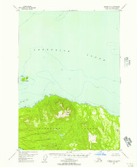
 1948 Petersburg D-61958 Print · USGSKake and the surrounding islands of the Alexander Archipelago are captured here shortly after the war, showing the area's coastal industry and maritime paths. Researchers can trace the Goldstein Trail and locate the historic cannery and Kake settlement.
 - 1951 Map of Petersburg D-6, 1964 Print
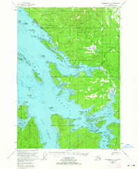 1951 Petersburg D-61964 Print · USGSSoutheast Alaskan island life in the early fifties is defined here by the coastal settlement of Kake and its neighboring waters. Researchers can trace historic paths like the Goldstein Trail and locate early industry at the Cannery on the edge of KUPREANOF ISLAND.3 unique versions available
 - 1952 Map of Petersburg, 1953 Print
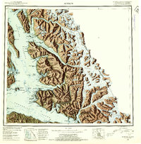
 1952 Petersburg1953 Print · USGSSoutheast Alaska's intricate Alexander Archipelago comes to life in the early fifties, documenting a landscape of remote island settlements and maritime corridors. Genealogists and historians can trace coastal life in Petersburg and Wrangell, or locate early industry at Shakan and regional Mines.5 unique versions available
 - 1952 Map of Sumdum, 1953 Print
 1952 Sumdum1953 Print · USGSSoutheast Alaska in the early fifties was a land of tidewater glaciers and isolated mining outposts. Researchers can trace the layout of remote coastal settlements like Windham and Sumdum or locate the historic Chuck Mining Camp near Endicott Arm.6 unique versions available
 - 1960 Map of Petersburg, 1966 Print
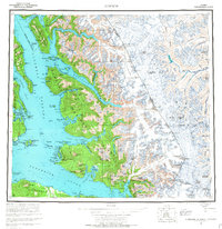
 1960 Petersburg1966 Print · USGSSoutheast Alaska's maritime landscape is captured here in the mid-1900s, showcasing the intricate island networks of the Alexander Archipelago. Researchers can trace historic shorelines and island settlements from Petersburg and Kake to the Wrangell Cemetery and the Stikine River.3 unique versions available
 - 1961 Map of Sumdum, 1967 Print
 1961 Sumdum1967 Print · USGSThe coastal wilderness of Southeast Alaska is captured here in the mid-twentieth century, showing a landscape defined by deep fjords and isolated maritime outposts. Researchers can trace early settlements and navigation aids like Windham, Jamestown, and the Five Finger Lighthouse.2 unique versions available
 - 1994 Map of Sumdum A-6, 1998 Print
 1994 Sumdum A-61998 Print · USGSSoutheast Alaska's maritime and forest landscape is captured here in the mid-1990s, showcasing the northern reaches of Kupreanof Island. Researchers can trace old resource extraction sites at various pits or locate navigational landmarks like Turnabout Island and Pinta Pt.
 - 1995 Map of Petersburg D-6, 1999 Print
 1995 Petersburg D-61999 Print · USGSKupreanof and Kuiu Islands are captured here in the mid-1990s, highlighting the maritime and timber economy of the Alexander Archipelago. Researchers can trace the layout of Kake, find remote sites like Big John Bay Cabin, and locate the Logging Camp Work Center.
 - 2017 Map of Sumdum A-6 SW, 2017 Print
 2017 Sumdum A-6 SW2017 Print · USGSCovers Kake, including Petersburg Borough, United States, and other nearby areas
 - 2017 Map of Petersburg D-6 NW, 2017 Print
 2017 Petersburg D-6 NW2017 Print · USGSCovers Kake, including Petersburg Borough, United States, and other nearby areas
 - 2021 Map of Sumdum A-6 SW, 2021 Print
 2021 Sumdum A-6 SW2021 Print · USGSSoutheast Alaska's coastal wilderness comes into focus in this recent survey of the intricate shoreline where the forest meets the sea. Researchers can trace the watercourses of Gunnuk Cr or locate maritime landmarks like Pinta Point and Turn Mtn.
 - 2021 Map of Petersburg D-6 NW, 2021 Print
 2021 Petersburg D-6 NW2021 Print · USGSThe village of Kake and its surrounding coastal waterways are documented here in the early twenty-first century. Genealogists and researchers can trace the local landscape around Kake Courthouse, Point Hamilton, and Silver Spike Road.
End of results
Showing maps 1-13 of 13
Frequently asked questions
- What are the different types of historical maps available for Kake?
- What is the oldest map of Kake?
- Where can I purchase historical maps of Kake for my home or office?
- Where can I download high-res historical maps of Kake?
- Are there historical topographic maps available for Kake?
- Is there historical aerial imagery available for Kake?
- Where are historical maps of Kake sourced from?