1900s (20th Century) Maps of Coffman Cove, Alaska
Explore 9 historic maps of Coffman Cove from the 1900s (20th Century). These maps offer a rare glimpse into what life looked like during the 1900s — showing old roads, neighborhoods, homes, and landmarks that have changed or disappeared over time.
Whether you're researching your family's past, planning a metal detecting trip, or studying how Coffman Cove's landscape evolved across the 1900s, these high-resolution maps are a powerful tool for exploring the history of this region.
- Focus on a specific era: All maps on this page are from the 1900s, giving you a focused view of this time period.
- See what’s changed: Compare century-old streets, trails, and buildings to today's modern landscape using overlays and satellite layers.
- Research with precision: Use these maps for genealogy, historical research, land use analysis, or educational projects.
- View, download, or print: Maps are fully viewable online in high resolution, and can be downloaded or printed for your own records.
Start exploring Coffman Cove's history through authentic maps from the 1900s. This is your window into the past.
Coffman Cove, AK maps
(9)- 1949 Map of Craig D-3, 1954 Print
 1949 Craig D-31954 Print · USGSPrince of Wales Island in the late 1940s was a roadless expanse of the Southeast Alaskan wilderness. Researchers can trace the original shoreline of Coffman Cove or follow the intricate drainage of Hatchery Creek and the Thorne River.3 unique versions available
 - 1949 Map of Petersburg A-3, 1964 Print
 1949 Petersburg A-31964 Print · USGSThe coastal waters of the Alexander Archipelago are captured here in the mid-twentieth century. Researchers can locate the Cannery (Aband) near Lake Bay and trace the maritime routes marked by the Steamer Pt Light.3 unique versions available
 - 1950 Map of Craig D-3, 1953 Print
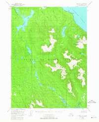
 1950 Craig D-31953 Print · USGSSoutheast Alaska in the mid-twentieth century is captured here as a maritime and mountain wilderness. Researchers can trace the original shorelines and interior basins including Sweetwater Lake, Coffman Cove, and the winding Thorne River.2 unique versions available
 - 1952 Map of Petersburg, 1953 Print
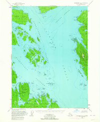
 1952 Petersburg1953 Print · USGSSoutheast Alaska's intricate Alexander Archipelago comes to life in the early fifties, documenting a landscape of remote island settlements and maritime corridors. Genealogists and historians can trace coastal life in Petersburg and Wrangell, or locate early industry at Shakan and regional Mines.5 unique versions available
 - 1953 Map of Petersburg A-3, 1954 Print
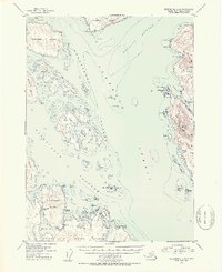 1953 Petersburg A-31954 Print · USGSSoutheast Alaska's maritime frontier is detailed in this mid-century survey of the waters between Etolin Island and Prince of Wales Island. Researchers can locate industrial sites like the Cannery at Lake Bay or trace the coastline of Zarembo Island.2 unique versions available
 - 1957 Map of Craig, 1959 Print
 1957 Craig1959 Print · USGSSoutheast Alaska’s intricate archipelago is revealed in the mid-1950s, detailing a coastal economy driven by remote mines and fishing outposts. Genealogists and historians can trace family roots in Craig, Hydaburg, and Klawak, or locate former sites like Tuxekan and the Salt Chuck Mine.3 unique versions available
 - 1960 Map of Petersburg, 1966 Print
 1960 Petersburg1966 Print · USGSSoutheast Alaska's maritime landscape is captured here in the mid-1900s, showcasing the intricate island networks of the Alexander Archipelago. Researchers can trace historic shorelines and island settlements from Petersburg and Kake to the Wrangell Cemetery and the Stikine River.3 unique versions available
 - 1994 Map of Craig D-3, 1998 Print
 1994 Craig D-31998 Print · USGSPrince of Wales Island in the 1990s reflects a balance of wild terrain and forest management infrastructure. Researchers can trace the Honker Divide Canoe Portage and locate backcountry outposts like the Sweetwater Lake Cabin (FS).
 - 1994 Map of Petersburg A-3, 1998 Print
 1994 Petersburg A-31998 Print · USGSCoastal life in Southeast Alaska's wilderness comes into focus during the 1990s as the timber and fishing industries left their mark on the archipelago. Researchers can locate remote Forest Service outposts like the Barnes Lake Cabin and industrial remains such as the Cannery Ruins and Log Transfer Facility.
End of results
Showing maps 1-9 of 9
Frequently asked questions
- What are the different types of historical maps available for Coffman Cove?
- What is the oldest map of Coffman Cove?
- Where can I purchase historical maps of Coffman Cove for my home or office?
- Where can I download high-res historical maps of Coffman Cove?
- Are there historical topographic maps available for Coffman Cove?
- Is there historical aerial imagery available for Coffman Cove?
- Where are historical maps of Coffman Cove sourced from?