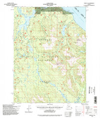
1994 Map of Craig D-3
USGS Topo · Published 1998About this map
Prince of Wales Island is depicted here during a period of infrastructure expansion within the Tongass National Forest. The City of Coffman Cove sits at the northern edge of this quadrangle, serving as a hub for the coastal and timber-related activity of the region. The map highlights a complex network of waterways and trails essential for navigating the Alaskan wilderness, including the Honker Divide Canoe Portage and the extensive reaches of the Thorne River. For those exploring the backcountry, the presence of the Sweetwater Lake Cabin (FS) and Honker Lake Cabin (FS) indicates the established forest service infrastructure used by hunters and travelers. The terrain is defined by prominent peaks such as Baird Pk and Manty Mountain, while the coastline along the Clarence Strait and Coffman Cove shows the maritime character of this remote landscape.
Find a feature on this map
34 named features on this map. Tap any name to fly to it.
Don’t see what you’re looking for? This feature index may not catch every label — zoom into the map to look around manually.
Map Details
Editions of this 1994 Craig D-3 Map
This is the sole edition of this map. No revisions or reprints were ever made.
Other maps of this area

1948 · Petersburg A-2
USGS Topo · 1:63,360

1949 · Craig D-3
USGS Topo · 1:63,360

1949 · Craig C-2
USGS Topo · 1:63,360

1949 · Craig D-2
USGS Topo · 1:63,360

1949 · Petersburg A-3
USGS Topo · 1:63,360

1949 · Craig D-4
USGS Topo · 1:63,360

1949 · Petersburg A-4
USGS Topo · 1:63,360

1949 · Craig C-3
USGS Topo · 1:63,360

1949 · Craig C-4
USGS Topo · 1:63,360

1950 · Craig D-3
USGS Topo · 1:63,360