1900s (20th Century) Maps of Thorne Bay, Alaska
Explore 4 historic maps of Thorne Bay from the 1900s (20th Century). These maps offer a rare glimpse into what life looked like during the 1900s — showing old roads, neighborhoods, homes, and landmarks that have changed or disappeared over time.
Whether you're researching your family's past, planning a metal detecting trip, or studying how Thorne Bay's landscape evolved across the 1900s, these high-resolution maps are a powerful tool for exploring the history of this region.
- Focus on a specific era: All maps on this page are from the 1900s, giving you a focused view of this time period.
- See what’s changed: Compare century-old streets, trails, and buildings to today's modern landscape using overlays and satellite layers.
- Research with precision: Use these maps for genealogy, historical research, land use analysis, or educational projects.
- View, download, or print: Maps are fully viewable online in high resolution, and can be downloaded or printed for your own records.
Start exploring Thorne Bay's history through authentic maps from the 1900s. This is your window into the past.
Thorne Bay, AK maps
(4)- 1949 Map of Craig C-2, 1962 Print
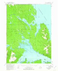 1949 Craig C-21962 Print · USGSPrince of Wales Island in the late 1940s reveals a rugged landscape of industrial mining and maritime trade. Genealogists and historians can trace the foundations of Kasaan or locate numerous extraction sites like the Salt Chuck Mine and the Cannery at the edge of the strait.3 unique versions available
 - 1951 Map of Craig C-2, 1953 Print
 1951 Craig C-21953 Print · USGSSoutheast Alaska's Kasaan Peninsula in the early fifties was a hub of maritime industry and mineral extraction within the Tongass National Forest. Historians can trace the legacy of copper and gold mining at the Salt Chuck Mine, explore the Cannery at Kasaan, or locate Indian Cabins along the Karta River.2 unique versions available
 - 1957 Map of Craig, 1959 Print
 1957 Craig1959 Print · USGSSoutheast Alaska’s intricate archipelago is revealed in the mid-1950s, detailing a coastal economy driven by remote mines and fishing outposts. Genealogists and historians can trace family roots in Craig, Hydaburg, and Klawak, or locate former sites like Tuxekan and the Salt Chuck Mine.3 unique versions available
 - 1994 Map of Craig C-2, 1998 Print
 1994 Craig C-21998 Print · USGSPrince of Wales Island in the 1990s reveals a coastal landscape defined by timber, maritime transit, and historical mining. Researchers can trace the industrial footprint of the Salt Chuck Mine, explore the Karta River Trail, and locate the early boundaries of Kasaan and Thorne Bay.
End of results
Showing maps 1-4 of 4
Top cities near Thorne Bay
Frequently asked questions
- What are the different types of historical maps available for Thorne Bay?
- What is the oldest map of Thorne Bay?
- Where can I purchase historical maps of Thorne Bay for my home or office?
- Where can I download high-res historical maps of Thorne Bay?
- Are there historical topographic maps available for Thorne Bay?
- Is there historical aerial imagery available for Thorne Bay?
- Where are historical maps of Thorne Bay sourced from?