Old Maps of Thorne Bay, Alaska for Metal Detecting
Plan your next treasure hunt with 12 historic maps of Thorne Bay. Find old homesites, ghost towns, trails, and gathering spots that may be lost to time — perfect for identifying promising metal detecting locations.
- Locate forgotten sites: Uncover places like long-lost settlements, abandoned rail lines, or gathering spots.
- Plan better hunts: Use map overlays combined with LiDAR or satellite views to narrow in on historically rich areas.
- Made for detectorists: Thousands of hobbyists use these maps to discover relics, coins, and hidden history.
Use these historic maps to boost your research and find new opportunities beneath the surface of Thorne Bay.
Thorne Bay, AK maps
(12)- 1949 Map of Craig C-2, 1962 Print
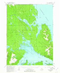 1949 Craig C-21962 Print · USGSPrince of Wales Island in the late 1940s reveals a rugged landscape of industrial mining and maritime trade. Genealogists and historians can trace the foundations of Kasaan or locate numerous extraction sites like the Salt Chuck Mine and the Cannery at the edge of the strait.3 unique versions available
 - 1951 Map of Craig C-2, 1953 Print
 1951 Craig C-21953 Print · USGSSoutheast Alaska's Kasaan Peninsula in the early fifties was a hub of maritime industry and mineral extraction within the Tongass National Forest. Historians can trace the legacy of copper and gold mining at the Salt Chuck Mine, explore the Cannery at Kasaan, or locate Indian Cabins along the Karta River.2 unique versions available
 - 1957 Map of Craig, 1959 Print
 1957 Craig1959 Print · USGSSoutheast Alaska’s intricate archipelago is revealed in the mid-1950s, detailing a coastal economy driven by remote mines and fishing outposts. Genealogists and historians can trace family roots in Craig, Hydaburg, and Klawak, or locate former sites like Tuxekan and the Salt Chuck Mine.3 unique versions available
 - 1994 Map of Craig C-2, 1998 Print
 1994 Craig C-21998 Print · USGSPrince of Wales Island in the 1990s reveals a coastal landscape defined by timber, maritime transit, and historical mining. Researchers can trace the industrial footprint of the Salt Chuck Mine, explore the Karta River Trail, and locate the early boundaries of Kasaan and Thorne Bay.
 - 2017 Map of Craig C-2 SW, 2017 Print
 2017 Craig C-2 SW2017 Print · USGSCovers Thorne Bay, including Unorganized Borough, Prince of Wales-Hyder, and other nearby areas
 - 2017 Map of Craig C-2 NE, 2017 Print
 2017 Craig C-2 NE2017 Print · USGSCovers Thorne Bay, including Unorganized Borough, Prince of Wales-Hyder, and other nearby areas
 - 2017 Map of Craig C-2 SE, 2017 Print
 2017 Craig C-2 SE2017 Print · USGSCovers Thorne Bay, including Kasaan, Unorganized Borough, and other nearby areas
 - 2017 Map of Craig C-2 NW, 2017 Print
 2017 Craig C-2 NW2017 Print · USGSCovers Thorne Bay, including Salt Chuck, Unorganized Borough, and other nearby areas
 - 2021 Map of Craig C-2 NW, 2021 Print
 2021 Craig C-2 NW2021 Print · USGSPrince of Wales Island in the early twenty-first century reveals a rugged wilderness of timber and tide within the Tongass National Forest. Researchers can trace the historic Honker Divide Canoe Route Trl and locate the settlement at Salt Chuck.
 - 2021 Map of Craig C-2 NE, 2021 Print
 2021 Craig C-2 NE2021 Print · USGSThe coastal wilderness of Prince of Wales Island is captured here in the early twenty-first century, showing the rugged edges of the Tongass National Forest. Researchers can trace the maritime geography of Tolstoi Bay and locate prominent landmarks like Thorne Head and Tolstoi Mtn.
 - 2021 Map of Craig C-2 SE, 2021 Print
 2021 Craig C-2 SE2021 Print · USGSCoastal life on Prince of Wales Island is centered around the village of Kasaan in this recent survey of the Alexander Archipelago. Researchers can trace the rugged shoreline from Mills Bay to Widtun Harbor or locate interior landmarks like Jacobs Mtn.
 - 2021 Map of Craig C-2 SW, 2021 Print
 2021 Craig C-2 SW2021 Print · USGSThe Prince of Wales Island coastline in the early 2020s reveals a wilderness of interconnected lakes and marine inlets. Local historians can trace established paths like the Karta River Trl or locate coastal landmarks such as Pellett Point and Nanny Bay.
End of results
Showing maps 1-12 of 12
Top cities near Thorne Bay
Frequently asked questions
- What are the different types of historical maps available for Thorne Bay?
- What is the oldest map of Thorne Bay?
- Where can I purchase historical maps of Thorne Bay for my home or office?
- Where can I download high-res historical maps of Thorne Bay?
- Are there historical topographic maps available for Thorne Bay?
- Is there historical aerial imagery available for Thorne Bay?
- Where are historical maps of Thorne Bay sourced from?