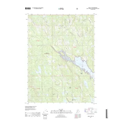
2017 Map of Craig C-2 NW
USGS Topo · Published 2017About this map
Prince of Wales Island is documented here during the late 2010s, showing a landscape defined by timber management and waterway access within the Tongass National Forest. The map centers on the reach of the Thorne River, including the Thorne River N Flats and its confluence with the Pacific Ocean at Thorne Bay. A complex network of forest service and logging roads, such as the Kasaan Road and Lake Ellen Road, provides access to numerous interior water bodies including Angel Lake, Lake Ellen, and Power Lake.
Find a feature on this map
61 named features on this map. Tap any name to fly to it.
Don’t see what you’re looking for? This feature index may not catch every label — zoom into the map to look around manually.
Map Details
Editions of this 2017 Craig C-2 NW Map
This is the sole edition of this map. No revisions or reprints were ever made.
Other maps of this area

1949 · Craig D-3
USGS Topo · 1:63,360

1949 · Craig C-2
USGS Topo · 1:63,360

1949 · Craig D-2
USGS Topo · 1:63,360

1949 · Craig C-3
USGS Topo · 1:63,360

1950 · Craig D-3
USGS Topo · 1:63,360

1951 · Craig C-3
USGS Topo · 1:63,360

1951 · Craig D-2
USGS Topo · 1:63,360

1951 · Craig C-2
USGS Topo · 1:63,360

1957 · Craig
USGS Topo · 1:250,000
1994 · Craig D-3
USGS Topo · 1:63,360