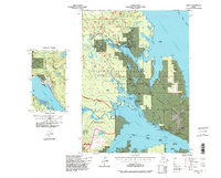
1994 Map of Craig C-2
USGS Topo · Published 1998About this map
Prince of Wales Island and the waters of Clarence Strait dominate this mid-1990s landscape, reflecting an era where resource extraction and conservation boundaries coexisted. The City of Thorne Bay appears as a center of local infrastructure, featuring a Water Treatment Plant and Sanitary Landfill, while the City of Kasaan sits further south on the Kasaan Peninsula. The industrial legacy of the region is evident through numerous historical workings, including the Salt Chuck Mine, Rush and Brown Mine, and the Poor Man Mine.
Find a feature on this map
77 named features on this map. Tap any name to fly to it.
Don’t see what you’re looking for? This feature index may not catch every label — zoom into the map to look around manually.
Map Details
Editions of this 1994 Craig C-2 Map
This is the sole edition of this map. No revisions or reprints were ever made.
Other maps of this area

1949 · Craig D-3
USGS Topo · 1:63,360

1949 · Craig C-2
USGS Topo · 1:63,360

1949 · Craig D-2
USGS Topo · 1:63,360

1949 · Craig B-2
USGS Topo · 1:63,360

1949 · Craig B-3
USGS Topo · 1:63,360

1949 · Craig C-3
USGS Topo · 1:63,360

1949 · Craig B-1
USGS Topo · 1:63,360

1949 · Craig D-1
USGS Topo · 1:63,360

1950 · Craig D-3
USGS Topo · 1:63,360

1950 · Craig B-1
USGS Topo · 1:63,360